Tag Archives: Metro

You can’t fight in here, this is the War Room!

Is Dr. Gridlock actually Dr. Strangelove?  He’s got a post up documenting the hearings going on right now on Capitol Hill, and not the ones dealing with potential Supreme Court justices.  The whole thing is full of colorful Cold War language:

The term entered the common language during the Cold War when Eugene Burdick wrote an arms-race thriller called “Fail-Safe.” The scenario seems dated now: To the stunned surprise of controllers, U.S. nuclear bombers move past the point at which they’re supposed to stop. But it’s still a ripper, because of the well-known principle the 1962 novel illustrated: If something can go wrong, eventually it will. Nothing built by humans is “Fail-Safe.”

The NTSB has already made their hypothesis known – that a glitch in the ATO system allowed the collision, even while operating in automatic mode.   What seems to have happened was a breakdown in the system where there was no redundancy – the failure of one system made it possible for the entire system to fail.

Dr. Gridlock continues with the Cold War imagery:

Metro’s operations control center isn’t as impressive as the Strategic Air Command’s headquarters, with its towering maps and flashing lights, but it’s basically the same function: Redundant protections are supposed to make the train system fail-safe. But ultimately, humans are making sure the equipment is going where it’s supposed to go.

On June 22, a fail-safe system failed to prevent the fatal crash of two Metrorail trains on Washington’s Red Line. And the National Transportation Safety Board told us on Monday that we have no system in place to ensure that this won’t happen again.

On a complete side note, I’ve always envisioned the operations center for Metro or any other large transit system to be like NORAD from WarGames or other Cold War movies.

(NORAD as depicted in WarGames – from PC Museum)

It’s the kind of place where all the super secret information is displayed.  You can’t let outsiders in there because they’ll see the big board!

Given Metro’s stark architecture and generous use of concrete, it’s not hard to envision a Kubrick-esque control room, complete with all the black and white imagery.

Joking aside, the substantive points from Dr. Gridlock’s post are that trains will be operating on manual for the foreseeable future.  The NTSB’s recommendation is the installation of a redundant train control system.  Such an installation would need to be specially designed for Metro, and obviously won’t be coming online in any short timeframe.

He also hits on one vitally important point – Metro is still the safest way to travel in DC.  It’s important not to forget that.

Canopies

(Image by Kyle Walton on Flickr)

Most of Metro’s station entrances these days have canopies to protect patrons and escalators from the elements.  It wasn’t meant to be this way, as Zach Schrag documents in his book The Great Society Subway.  For numerous reasons, however, we have them now.  With that in mind, DC Metrocentric has a recent post up on the elegance of the canopies at Columbia Heights – how they blend in to the surrounding area, fit well with the nearby architecture, etc.

I can’t help but comment on these canopies – because I really dislike the Columbia Heights (and Petworth, for that matter) canopies.   Unlike the other canopies in the system, these ones may look fine from the outside, but they violate a number of the basic design precepts of the entire system.  There’s something to be said for individualized stations and station entrances, but for better or for worse that’s not part of the Metro system.  Instead, Metro is marked by remarkable continuity between stations with common design elements and common materials.

One of those core principles is to maximize volume. This isn’t just for grandeur, either – the voluminous train rooms in Metro’s underground stations provide clear sight lines for patrons to see the mezzanines and easily visualize the circulation routes to get in and out of the stations.  Similarly, Metro designers explicitly wanted to stay away from associations with older, enclosed systems in Philly, Boston, Chicago and New York – that meant fare gates are unobtrusive, unlike their caged cousins in New York.

The Columbia Heights canopies violate a couple of these points.  Though they enclose a lot of space, they sure don’t feel voluminous.  Because the canopies sit rather low on the station’s parapet, the gap between the outside and the escalator shaft feels enclosed.  It doesn’t help that the gap is enclosed with a combination of public art and metal bars.  It feels more like a cage than a canopy.

(Image by dbking on Flickr)

Where older metro entrances have their ‘doors’ and gates used to close the system at the bottom of their escalator wells, these stations have them at the top of the escalators as part of the canopy.  This necessitates the caged feeling, since it functionally is a cage.  Undoubtedly, this is done to eliminate homeless people sleeping at the bottom of the escalators but the effect is detrimental to the overall design.

Finally, these canopies don’t identify which part of the structure is the entrance.  This isn’t a huge critique, because the canopy-less stations have the same problem.  However, given the fact that the canopies do exist, the more common design does a much better job of identifying where to enter the system simply by design.

(Image by dbking on Flickr)

The soaring canopy fits Metro’s design much better.  It provides the necessary shelter for both people and equipment, maintains the openness of the station entrances, clearly indicates where one enters the station, and harmonizes well with the rest of the system’s architecture.   The ‘scooping’ of the canopy clearly indicates which end is the entrance.  The curvature of the canopy, combined with the individual panes of glass evokes a clear parallel to the original coffered vault station design.

For freestanding station entrances, this is the better option.

However, they’re not a cure all.  The U Street Metro’s 13th Street entrance is a great example.

Here, the canopy ‘opens’ to a wall.  Not so good.  Perhaps a better option would have been to integrate the station entrance into the structure itself, as is done quite successfully in several downtown stations.  This also would have been a viable option for the Columbia Heights stations and might be a more functional way to achieve the individuality for each station that DC Metrocentric wants.   Not every entrance should be a grand plaza.  It works in some spaces (like Eastern Market, where the plaza is already there), but in others it can be detrimental.  Potomac Ave is a great example – there’s plenty of open space in the adjacent square that could be far better utilized.  The plaza around the station itself is underutilized.  If the land could be developed and the station accessed via a ‘retail’ storefront kind of entrance, the station area itself would gain density and uses, as well as improvements to the urban deisgn of the area.

Links – Harumph.

The Urbanophile makes no little plans with a nice review and synopsis of transportation’s role in Daniel Burnham’s famous Plan of Chicago.   As someone born and raised in the Midwest, I’ve got a soft spot in my heart for Chicago.

His “City Beautiful” movement can also easily be read as a precursor to urban renewal. Indeed, a good chunk of his plan consists of Robert Moses like street building and street widening projects, many of which were in fact carried out. And he drew direct inspiration, and even claimed inspiration in the document itself, from Hausmann’s bulldozing of the Paris to construct the grand boulevards there.

On the other hand, writing in 1909 he can perhaps be forgiven feeling overly optimistic about the automobile, and the more humane side Burnham shows through in many places as well. So let’s take a look.

Given DC’s abundance of very wide streets, widening them isn’t reason alone for a bad plan.  Indeed, many of Burnham’s widened streets, even if the goal was to better accommodate the car, function today as grand avenues.  Michigan Avenue in particular comes to mind.  Moses, on the other hand, brought in expressways.  What a difference 30-40 years makes in both the evolution of the automobile, as well as the evolution of road design.

Lake Shore Drive has a more mixed legacy – it’s definitely more in the “parkway” mold of Moses’ freeways, but other elements of the plan (such as the double decker streets downtown) are functional for both cars and pedestrians alike.  Wacker Drive not only provides great backdrops for the Blues Brothers and Batman, but it’s a fine public space as well.

Another relevant note and similarity Chicago shares with DC:

“The greatest disfigurement of the residence street is found in the varied assortment of poles which crowd out the trees along the space between the curb and the sidewalk.”

One thing that cannot help but strike any visitor to Chicago is the near complete absence of utility poles apart from street light standards on streets. And not just residential streets, but commercial streets. This is extremely rare in the United States. Chicago has more alleys than any city in America, and its power, telephone, and cable lines are located there. (As is its trash – take that, New York!).

Amen.  It’s just too bad that DC’s overly restrictive legislation against overhead wires inhibits development of streetcar networks, etc.

Chicago is a huge city, but it often doesn’t feel that way. Get out of the core and you find streets full of mature trees and greenery exceeding that found in much smaller places. This is no concrete jungle. It is a city for people.

As someone who grew up in the Midwest, Chicago always felt like the “big city,” but was definitely still Midwestern in vibe.  It’s a truly remarkable city, and this observation is spot on.  The neighborhoods feel welcoming and fit in to the larger city like lock and key.  It’s a similar feeling I got upon arriving in DC.  My previous experience had been almost totally federal, without any real exploration of DC’s neighborhoods.

The only real parallel is that DC never has (to me) that same kind of Big City feel that Chicago does – but much of that is due to Chicago’s dominance over its region.  Nevertheless, it’s a great place to visit.

Thank you sir, may I have another! Randal O’Toole continues to get lambasted amongst the pro-urban bloggers.  The Overhead Wire weighs in on Ed Glaeser’s op-ed piece – comparing it to O’Toole’s work (for someone of Glaeser’s accomplishment, that’s not a compliment), and Ryan Avent takes a shot at O’Toole’s recent testimony before Congress:

The performance earned dismal reviews. One by one, the other witnesses pointed out that failure to adequately examine land use effects rendered O’Toole’s analyses worthless.

Mode choice isn’t just about direct energy use, they explained; it’s about how increased driving or transit use affects development patterns and broader economic activity. Moreover, increased transit use improves the efficiency of driving by reducing congestion.

It’s great to see O’Toole’s ‘analysis’ get this kind of treatment not just from bloggers but from the fellow panelists as well (and even a Senator or two).

O’Toole was without friends in a room of leaders that finally seemed to grasp how planning had gone wrong in the last half century. At this moment — with vehicle miles traveled falling, with central city population growth rates increasing as suburban growth rates fall, and with central city housing prices showing resilience as exurban neighborhoods continue to experience rapid decline — Cato’s myth of sprawl as the American dream seems more hollow than ever.

Happily, legislators — at least those who attended today’s hearing — increasingly seem disposed to acknowledge reality.

That’s great.  Now, about turning that thought into action…

Maps. GGW and BDC have a couple of posts on GGW’s publication of several MWCOG maps of home locations of employees based on where they work.  The patterns are quite interesting, showing how people tend to cluster their homes nearby their place of employment, regardless of transport mode.  Thus, for employees in DC’s downtown Federal buildings, their home choices are located around Metro.  NIH employees tend to congregate on the Wisconsin Ave/Rockville Pike corridor, etc. Similarly, suburban job centers like Reston still show a great deal of concentration, but not nearly as tight as the transit-oriented locations.

BDC’s policy takeaway:

Think those downtown workers are the ones clogging I-66 and I-95? Not likely. The situation could not be more clear: If you want to foster Smart Growth and multi-modalism, put your jobs in the city. If you want to foster sprawl and congestion, put them far away. End of story.

I would add that within our current framework of transit corridors and job centers, continuing to try and transform an area like Tysons Corner into more of a city is worthwhile.  However, consider the rest of Tyson’s Silver Line neighbors – transforming the Dulles Corridor into something more like Rosslyn-Ballston well after the fact is going to be easier said than done.  We don’t have much choice but to try, but running a subway down the median of a freeway isn’t going to produce the best results.

Random Stuff:

  • Austin Contrarian looks at the relationship between the skill level of employees in cities and the density of that city.  Bottom line – more dense, more skilled – and the relationship is particularly strong when you look more at the weighted density of an area.
  • Housing Complex looks at the plans for Rhode Island Ave, starting with some woefully underutilized land near one of the original 1976 Metro stations.   Fun facts to know and tell – Brentwood has the highest elevation of any station in the system.
  • Metro operators probably shouldn’t be texting while driving.

A New Square for Potomac Ave – Part II

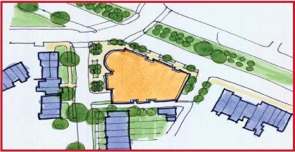
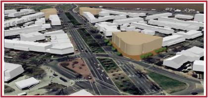
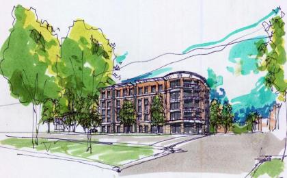
Following up on the vision for the public space at the Potomac Ave Metro station, I wanted to offer a glimpse at what the square might look like in the future.  All of the great squares, circles, and other urban spaces are not just defined by their public spaces, but also by the buildings that frame the space.  With the addition of Jenkins Row to this intersection, Potomac Ave is approaching both a complete streetwall around the square, as well as the critical mass of various neighborhood services.

With that in mind, I turn to the draft of the Pennsylvania Avenue SE Land Development Plan.  Of specific interest for this intersection is the Potomac Ave sub-area plan.  This iteration identifies the 1401 Pennsylvania parcell as a key redevelopment opportunity.  A quick glance at the area will quickly identify the SE corner of the square as the weak link, containing a couple of vacant lots, a parking lot, and New York Pizza.  Living in the area, I love what NY Pizza brings to the ‘hood, so I would sure hope that any redevelopment helps them find a new home.  Even so, you can totally tell it used to be a Pizza Hut.

With Jenkins Row filling in the old gap on the eastern edge of the square, this parcel is the one missing link (aside from the Metro station plaza).  As such, the plan calls for new mixed-use construction at the side in the same mold as the Jenkins Row development – first floor retail with office and/or residential above.

Potomac Ave Plan

(Plan view)

Potomac Ave Massing

(Massing perspective)

Potomac Ave Sketch

(Concept sketch)

A couple of points stand out.  First, when combined with the reconfiguration of the intersection’s traffic flow, buildings fronting on the new square ought to see more foot traffic – at a very least, the sidewalks they front on should be far more attractive to pedestrians walking either around the square or passing through it.

Second, the current Metro plaza, as mentioned above, would then be the one missing part of the streetwall enclosing this square.  Given that the station is such a focus for foot traffic, this is fine – but one potential benefit is that a taller structure on the 1401 site is directly in the line of sight of Metro patrons coming out of the station’s escalator well.

All together, such a project could be the keystone in the arch for this public space.  As of right now, I’m unaware of any specific plans for the site.  I’ll just enjoy my pizza until then.

But seriously, if this site does get developed soon, you gotta keep the pizza.

Metro Fantasies – now with pictures

Following up on my previous comments about Metro expansion and a new Yellow line, I wanted to add some graphical representation of these ideas.

First, the current Metro system:


View DC Metro in a larger map

My plan includes the Silver line as currently planned and under construction, as well as my conception of the new Blue line (shown in teal) as well as a separated Yellow line (shown in Goldenrod), with separation from both the Green like through DC and from the Blue line through Arlington and Alexandria.  The new lines only are here:


View DC Metro Expansion in a larger map

Combine both the current system and the new plans, and you get this:


View Combined Metro Map in a larger map

Old tracks are in blue, new tracks in yellow.

Obviously, these maps have no stations (yet).  It’s safe to assume that where two lines cross, you’d want to have some sort of a transfer station there.  With new lines crossing (thinking specifically of the intersection of North Capitol and H St), you could have a brand new Metro Center-esque station, linked by tunnel to the current Red line stop at Union Station.

The purpose of putting these lines on these streets is merely to define the corridors and ensure some feasiblity in terms of potential rights of way and station areas, but they shouldn’t be considered concrete decisions.

Adding to Metro’s Core Capacity

Greater Greater Washington’s always had some great fantasy transit discussions – whether talking about the New Blue line, more fantastic visions, or even the multimodal vision for Baltimore and DC.  Over the last few days, the fantasy discussions have started again.  Though these are not always the most realistic discussions, they’re a great starting point for larger discussions about the role of transit in the transportation system in the city, and more importantly they discuss what kind of city we want to have.

This past week’s discussions have focused on the idea of a new Yellow line – originally posted here, along with my response.   The entire premise of separating the Yellow line from the Green line (at least as I understood it) was to increase the maximum capacity of both lines – the same premise behind the idea of separating the Orange and Blue lines.  That way, both colored lines would have full capacity for their entire length.  Doing such a project would also have ancillary benefits, such as adding redundancy to the system with multiple tracks on fairly similar routes, as well as opening up new areas to Metro service (such as adding Metro service to H Street NE with the New Blue line).  Each of these ideas is worthwhile, though slow to implement.  Given the facts that Metro is already straining to handle the crowds along the Orange line though the RBC, focusing on this kind of long term planning is important.  Building new subway lines will take a long time, and with Metro expected to reach capacity sometime between 2025 and 2030, starting the planning process now is vitally important (i.e. Metro was recommended as the preferred alternative for the Dulles Corridor in a 1997 report – the full line is now set to open in 2016 – nearly 20 years after the fact).

With that in mind, proposals that involve a great deal of capital construction must have a long term plan behind them to justify the investment.  The idea of separating the Blue and Orange lines is a good start.  Having a longer term plan to separate the Green and Yellow lines is also a good idea – even better would be to combine those efforts sowe have a nice 50 year map to follow for Metro’s development over time.

The lack of this kind of focus and long term vision troubles me with GGW’s latest series of posts about adding new trackwork in downtown DC.  The premise is a simple question: is there a simpler and cheaper way to add core capacity to Metro without building the entire New Blue line?

How about separating the Yellow Line instead? The Yellow Line plan Dave Murphy suggested last week, and some of your comments, suggest a possibility. If we separate the Yellow and Green lines in DC, then Metro could put many more trains over the 14th Street bridge. According to Metro planners, this option would involve building a shorter subway tunnel from the 14th Street bridge to the Convention Center along 9th Street.

While the tunnel at Rosslyn is already at its capacity, the 14th Street bridge isn’t, because all its trains must merge with Green Line trains from Branch Avenue. Metro can squeeze a few more Yellow Trains in if they reduce Blue trains, but not that many. If the trains didn’t have to compete with the Green Line, the 14th Street bridge could carry many more trains from Virginia.

The second iteration of the idea also generated a great deal of discussion:

If we could run more trains over the 14th Street bridge, where would they go in Virginia? I can see two possibilities: convert the Arlington Cemetery segment to a shuttle train, or add connections to route the Silver Line over that segment as well as the Blue Line.

Both of these ideas are intruiging from an academic perspective, but completely lose sight of why you’re adding core capacity in the first place.

Remembering that the whole point of the New Blue line is to separate it from the Orange line tracks it shares through DC, the reason it gets brought up first is due to the popularity of the Orange line in Northern Virginia.  This GGW idea is an attempt to solve that same problem by essentially starting on a new Yellow line.  You’re essentially building half a subway, except that you’re building the New Yellow line first when the Blue line is the obvious choice.

If you’re going to put shovels into the ground, you might as well make sure that the plans have long term significance.  Metro’s genius is that it was concieved as an entire 100 mile system.  Even so, it functioned well before the full system was complete.

WMATA should take the same step here.  If you want to add new capacity to downtown DC by building half of a new subway, just start building the new Blue line – and do it in phases.  The first phase (say, from Rosslyn to the Connecticut Ave station) would accomplish the same thing – freeing up core capacity on the Orange (and Silver) line, as well as delivering Blue line riders to the core of downtown.   However, unlike the 9th street proposal, the Blue line would be readily expandable at a later date, much like how the Mid City portion of the Green line was completed in phases (with U Street opening in 1991, while Columbia Heights didn’t open until 1999).   Ideally, you’d like to do it in one fell swoop, but the entire premise of this idea is that the funds to do such a project aren’t there.  So let’s at least plan it with expansion in mind.

With that said, the idea of a new Yellow line isn’t a bad one at all, even if the timing isn’t quite right.  However, using 9th street doesn’t make a lot of sense when you already have lines along 7th and 12 streets downtown, and along 14th street in Columbia Heights.  The alignment proposed in the original post makes a lot more sense when viewed with a long-term lens.  A 9th street alignment would indeed be redundant, but almost too redundant – it wouldn’t open up any more area to Metro service, such as the transit poor Washington Hospital Center.  A North Capitol/Georgia Ave route would provide redundancy for both the eastern Red line, the whole of the Green line, and open up a major commercial street to Metro.  This line could also be phased in over time, initially operating as just a partial segment.

As Burnham said, “make no little plans.”  If you’re looking for incremental physical improvements, I’d opt to ensure that they’re part of a larger plan.  The final result will be far better for it.

Fantasies

Dave at Imagine DC (and also GGW) put up a nice concept of a separated Yellow line through the core of DC.  Separating the Blue line has been the most popular suggestion, and was originally among WMATA’s official plans, but the idea of separating the Yellow line is relatively new.   Still, amongst extensive discussion in the comments from previous fantasy maps, the idea has come up before – my name is somewhere in those comment threads.

Given the focus that Monday’s accident has put on redundancies in the transit system, it’s fitting to consider the idea.  However, it’s important not to lose sight of the reasons for such plans and expansions in the first place.  With that in mind, I’d propose a few key principles to consider for any metro expansion plan:

  • Separation of the current interlined portions of track.   The proposals to separate the Blue and Yellow lines certainly do this, and for good reason.  The ‘tail’ sections of each line are limited by the capacity of the shared track at the core.  Furthermore, the complexities of switching so many trains on and off the same line only adds to potential delays.  Separating these lines would offer wide ranging benefits to other lines in terms of increased service frequencies.
  • Plan the entire system now.  By ‘now’ I don’t mean today, but if plans are drawn up to implement this kind of expansion, it is vitally important that the lines are planned together.  The fact that all 100+ miles of Metro were planned as a coherent system is what makes it such a useful system today, rather than a hodgepodge of individual lines.  If you look at the poor connections between Baltimore’s light rail and subway, you’ll see precisely what you wish to avoid.  That means planning to separate the Blue & Orange lines, the Yellow & Green lines, and the VA portions of Yellow & Blue at roughly the same time.  Doing so, like the original system, will allow for transfers to be built in and will make for a much better overall system.  Begin with the end in mind.
  • Learn from Metro’s past. Metro’s hybrid nature as both an urban subway and a suburban commuter rail system makes for some interesting compromises in terms of system design.  Given that the newer portions would entail track mostly in urban areas, it’s important to apply the lessons of Downtown DC, the Rosslyn-Ballston corridor, and others.  This is about urban transit, not park and ride stations.
  • Coordinate plans with other modes. Metro expansion should focus on the core because that’s where it’s most useful and can justify the cost.  Ideas like extending the Orange line to Centreville, or the Green line to BWI miss the opportunity to have a newly beefed up regional rail system operating in place of MARC and VRE trains.  Ideally, such Metro expansion plans would be coupled with a transformation of the commuter rail services into a more S-Bahn like system.  In the other (more local) direction, coordination with streetcar planning is also vital.

Speaking in terms of broad corridors, Dave’s plan for the Yellow line is spot on.  I think he’s got too many stations for a heavy rail line, but the general corridor is correct – the line would use the same bridge over the Potomac, then go underground and follow the Maryland Ave right of way, linking to L’Enfant Plaza with a new platform for the station complex.  The line would cross the Mall, then travel north under North Capitol, including a station at H street – which would also be part of the station with the new Blue line – also connecting to the current Union Station stop (hence the importance of planning these lines at the same time).  The line should go up to the Washington Hospital Center, serving that major employment center, then sliding to the west somehow to turn northward again under Georgia Ave.  After reaching Silver Spring, the line can either end there, or continue north along US 29, as proposed by Sand Box John.

The Blue line has been discussed many times – I think the best alignment would be across town under M street, angling southward under New Jersey Avenue, and then continuing east under H street – ideally with transfers to the Red line at both Union Station and under Connecticut Ave, as well as a Green line transfer at the Convention Center and a transfer to the new Yellow line near the Union Station complex.

Separating the Blue and Yellow lines in Virginia is probably the easiest route to conceptualize – simply shooting the line outward under Columbia Pike is the most obvious choice, making the current line to Alexandria one ‘color’ with multiple spurs – one to Huntington and one to Franconia-Springfield.

Track Circuit Didn’t Work

News today that the track circuit underneath the stalled Metro train in Monday’s crash failed:

The track circuit below the Washington Metro train that was rear-ended by another train this week didn’t work, U.S. transportation safety investigators found in a test.The circuit was supposed to relay information about the location of trains. The National Transportation Safety Board is investigating the June 22 accident in which nine people died. It was the worst in the 33-year-old Metro system’s history.

The circuit, part of Metro’s automated operations system, didn’t detect the presence of a test train investigators placed on it, the board said today in an e-mailed statement.

My speculation: In effect, the system didn’t know the stalled train was there.  Hence, it accelerated the back train and sent it at normal speed into a section of track the computer thought was clear.

The disturbing part would seem to be not the ATC system, but the fact that the sensor didn’t work.  ATC is a relatively new thing for railroads, but track sensors are not.  They work by sending a small current through each rail – tracks are divided into separate sections called blocks, and when a train’s wheels enter a block, the metal axle completes the circuit, sending a message to the control center on the train’s location.  This kind of technology has been in use for a long time.

The question is whether the failure is a part of the ATC system or the trac circuits.  Either way, it’s becoming more clear that the ignalling/control failure is primarily responsible here.

Metro Crash Aftermath

In the wake of Monday’s Red Line crash, DC’s various news outlets have uncovered all sorts of interesting factoids about Metro’s safety record and the implementation of various NTSB recommendations.  Speculation about the causes have run rampant, ranging from mildly informed theories to pure guesswork.  Some immediately blamed the now deceased operator, citing likely use of a cell phone.  DCist now reports via WTOP that’s not the case.

There’s also been a lot of discussion about the 1000 series rail cars and their crashworthiness.  At Greater Greater Washington, Matt Johnson has an excellent summary of Metro’s safety systems, particularly noting the design of the Automatic Train Control system as well as the track record of the 1000 series rail cars.   WCP gives you tips on how to avoid them, while the WMATA board agrees to move the cars to the middle of trainsets.

Public interest seems to focus on the 1000 series rail cars as the culprit, even though there’s no evidence that the cars themselves were the cause of the crash.  To me, the more interesting news to come out was the City Paper’s report that the NTSB found “anomalies” in the trackside equipment that’s part of the automatic train control system:

‘Anomalies’—that’s what federal investigators found in trackside electronic control equipment during testing yesterday, ’suggesting that computers might have sent one Red Line train crashing into another’ on Monday evening, WaPo writes. More from Lyndsey Layton, Maria Glod, and Lena H. Sun: ‘A senior Metro official knowledgeable about train operations said an internal report confirmed that the computer system appeared to have faltered.’ And that system, according to the NTSB’s Debbie Hersman, is ‘vital.’ Then there’s this: ‘The steel rails show evidence that McMillan activated the emergency brakes 300 to 400 feet before the pileup’—but she would have been traveling 59 mph. See also WTOP, NC8, WRC-TV, WUSA-TV, WTTG-TV, NYT, and Examiner, which notes that brake maintenance seems no longer to be an issue.

Again, it’s important to separate the two issues in this crash – the events that caused the crash itself, and the impact of the crash and the aftermath.  The former is about why this happened in the first place, the latter is about the crashworthiness of the cars.  Crashworthiness is important, without a doubt – but it’s also about keeping things as safe as possible after something has already gone wrong.

For that reason, the events that caused the crash itself are far more interesting to me.  We have evidence that the train was operating on Auto mode, that it was traveling quite fast (though eyewitness accounts tend to vary as to how fast – nevertheless, the damage shows a great deal of force was involved).  Given the slight curvature of the track, the speeds involved, and human reaction time to depress the Mushroom, it seems we can infer that the collision was unavoidable at that point – which would point to a very serious error with the Automatic Train Control system.

That’s where my interest is as the investigation unfolds.