Tag Archives: Links

Garden Variety Links

Garden Cities – Suburbs, back to the future…

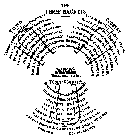
Christopher, in the comments of my post on the American Dream, mentioned this great photo gallery over on Slate from Witold Rybczynski of Forest Hills Gardens, an American interpretation of the Garden Cities of the turn of the century.  Chris notes these Garden City suburbs have all of the principles of today’s New Urbanist communities – transit orientation, sufficient density, mixed uses and mixed incomes, etc.

It’s all about access

Cap’n Transit continues on his campaign for transportation to focus on accessibility over mobility.  The two concepts, of course, are intricately related, but accessibility is the more important paradigm for urbanism and city life:

Last week Grist had a well-sourced article (which came to me via Planetizen, via Portland Transport, via Streetsblog.net) that nicely illustrates how improving access without mobility can get people to drive less. And of course by driving less, we reduce pollution and global warming, increase energy efficiency, and all the rest. In this case, when stores are located within walking distance, people walk more, improving their health as well.

Transportation planners should be willing to acknowledge when there’s a possible non-transportation solution that’s worth considering, especially when they’re dealing with taxpayer money. They should then be prepared to say, “You know, you really need a business development planner. That’s not my specialty, but let me introduce you to Joe, who’s really good at fostering downtown businesses.”

This kind of integration between professional disciplines ought to be the goal.  Of course, that’s easier said than done.  Nevertheless, fostering regulatory environments where such holistic understandings of urbanism, transportation, and the interconnections between them ought to be encouraged.

At the same time, I don’t think we need a complete revamp of the current system – but encouraging these conversations and spreading these concepts amongst the population at large is important for planners and urbanists.

Great Station Architecture

Aaron Renn has a post on the potential of Chicago’s El and other transit systems to be not just good, but great.  At the end of the post, Renn has a great collection of photos from various transit systems around the world – showing off great station architecture and high-minded design.  The gallery is well worth a look.

Within that discussion, Matt Johnson has a fantastic set of posts at GGW on the basic design elements of Metro’s system (part one – underground stations; part two – above-ground stations; part three – other motifs).  Matt lays out the basic elements of Metro’s stations and how they’re both constant yet varied within the system.

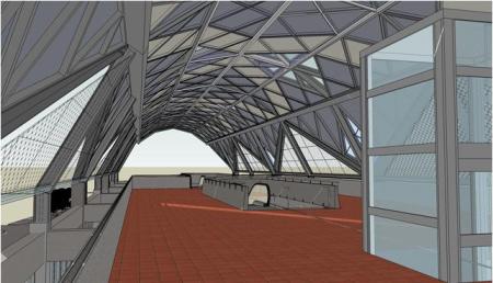
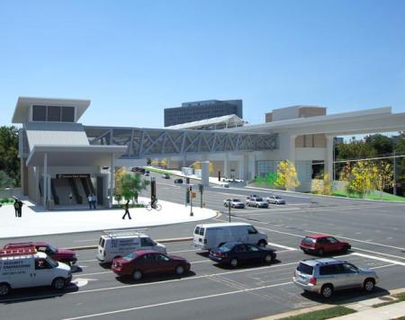
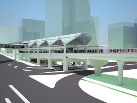
When it comes to creating great stations, DC’s immediate opportunity will be on the Silver line.  Discussion in the comments asked about the sole underground station on the new line (at Dulles), but since that station is in the second phase of construction, we don’t have renderings of the architecture – just some basic engineering.  We do have, however, renderings from the stations in phase one – and the comments in part two of GGW’s thread weren’t exactly complimentary of the architecture.

Some photos from the Dulles Metro website:
TysonsCentral123

Tysons Central 123

Tysons7int

Tysons Central 7 – interior

TysonsEastExt

Tysons East

In other station news – over in Vienna, Jarrett Walker has a post on station architecture there – focusing on the Art Noveau elements.

While we’re in Vienna…

Jarrett also has some posts on other elements of Vienna’s transit systems.

First, he has a follow up on the city’s overhead wires. Jarrett’s great photos allow the reader to decide if those wires ruin the city or not.  My opinion is that they do not, and they won’t mean the end of the world for DC, either.  That is, once we decide to bring our new streetcars back from the Czech Republic.

Jarrett also notes about the excellent network effects within Vienna’s system – including cross-platform transfers.  Making transfers easy is an important part of a great system – even in DC, plenty of people I know hate to switch lines, especially at off-peak hours when trains run more infrequently.  Jarrett notes:

In talking about transit planning I’m constantly stressing the need to think in terms of interconnected two-dimensional networks, not just the one-dimensional “corridors” that are the focus of so many transit studies.  It’s a hard point to convey because (a) interconnectedness implies connections, also called “transfers,” which people supposedly hate, and (b) networks are complicated and abstract and hard to think about, which is why I’m always trying to create and promote tools for making them simpler.

What’s more, network effects are really hard to photograph.  The closest you can come is a photo of a really smooth cross-platform connection.

A cross platform transfer allows a rider to switch lines by simply crossing the platform to a different train without having to switch levels, as you currently have to do at Metro Center or the other main DC transfer points.  This diagram from Wikipedia shows how a cross-platform transfer works in Hong Kong’s MTR:

Basically, the train lines weave for you – thus the passenger does not have to navigate stairs/escalators to get to a different platform to switch lines.   Each train stops twice in this one ‘station’ – one stop facilitating a transfer to the other outbound line, the second to the other inbound line.

Jarrett also references one of his other posts, where he notes why transfers are good and why we should try to make them easy – they really make the system as a whole function smoothly.

Moving Time

Moving boxes by carlaarena on Flickr

Moving boxes by carlaarena on Flickr

Posting’s been light the last couple of days because I’ve been moving from one house to another.  No matter how many times I do it, I still forget what a pain it can be.  Now that I’m finally settling into the new digs, there’s been a whole lot of things worth commenting on posted in the past few days.

First, Richard Layman gave me a link on his blog, noting that we tend to disagree on a couple of things.  Though Richard and I do diverge on a number of issues, I think it’s worth noting that we’d agree on far more topics than not – including the general overall direction for the District and cities in general.   I’d also point out that a trend I notice in blog commenting in general (and many of my comments in particular) is that the truncated nature of the medium tends to focus my comments on one or two ideas from a post, and too often those ideas are critical rather than positive.  That’s the nature of the beast, I guess.

Thanks to Richard for having so much great info on his blog, I appreciate the link.

Poplar Point is a popular discussion item again.  GGW summarizes the development options presented, and Richard Layman chimes in.  Both note that all the options leave a little something to be desired.  One thing none of them have, however, is a soccer stadium – yet.  DC United officials have been chatting with Akridge about property they own, and is apparently still talking to DC officials about Poplar Point – though no one wants to admit anything.

All this stadium talk triggered a response from Noah Kazis at The City Fix.

While it’s good to see the Journal’s real estate blog thinking about neighborhoods rather than just individual sites, this is a common misunderstanding of how stadiums work. They aren’t vibrant providers of economic development; rather, they sit empty most of the time. The D.C. United schedule calls for 30 games a year, only 15 of which will be at the United’s stadium (not including playoffs, exhibition games and the like). That’s not enough to really spark development. While a built-in market of absolutely packed crowds at your sports bar is great for those 15 nights, the rest of the time you’ve got an enormous empty structure that will inevitably be surrounded by at least some large parking lots. That’s not a draw for street life.

First, I want to address a factual item.  DC United’s league schedule only has 15 home games, but DC United plays in several competitions beyond just MLS each year.  Just this past Tuesday I was in attendance at RFK for a game in the CONCACAF Champions League.  DCU also plays in the US Open Cup every year, plus there is also the SuperLiga, international friendlies, and plenty of games between National teams.  RFK will host the US Men’s National Team three times this calendar year, and has already played host to international matches between two non-US nations – drawing good crowds, too.

This issue of the number of games each year often is mis-stated, as most American sports fans don’t have experience with the idea of multiple, concurrent competitions as is commonplace in soccer leagues across the world (including MLS).  Most North American pro sports have their league’s regular season and then the playoffs – and that’s it.  Soccer has a whole lot more on the schedule, and it’s important to note that.

Still, I don’t think this changes the end result of Noah’s analysis.  Stadiums aren’t great for developing streetlife per se, but they can be an anchor to draw in crowds that would otherwise never venture into that part of the city.

I’d also argue that justifications for sports stadiums on pure economic grounds are misplaced from the start.  Sports are an important part of the civic identity of a city, and it’s important for cities to foster that connection.  Going so far as to hand over an expensive stadium on a silver platter (Nationals Park) probably crosses the line, but there’s something to be said for being a “major league” city.  DC United shouldn’t be an exception.

K Street’s transitway plans are moving forward, and not a moment too soon.  The two options at this point:

One option would create a two-lane busway in the center of K Street, leaving three general-purpose lanes on each side. The other option, on the other hand, makes the transitway three lanes, where the third lane lets eastbound buses pass each other in some spots and westbound buses pass each other in other spots. That option also contains a bicycle lane along the length of K Street. While at first glance the plans seem to provide a clear choice between more accommodation for cars versus more for buses and bikes, the difference isn’t that simple. Making a true “complete street” that works for all modes is not easy.

A nice debate emerged in the comments about bike lanes vs. trees vs. transit.  Leaving that discussion of priorities for another day, I’d offer one comment – I’d like to see a plan that can accommodate rail transit and buses on the same transitway in the space at the same time.  Seattle recently started doing this as they converted their downtown bus tunnel to handle both light rail and bus operations:

For any plan, I’d like to know how it could translate to rail in the future.  I would think that having some passing sections might facilitate streetcar, light rail, and bus operations.

Speaking of streetcars, Jarret Walker has a couple of great posts following up on the ‘debate’ between mobility and accessibility.  Also, along the same vein as trying to define the terms we use when discussing these issues, he has a great post about transportation planning in Australia and determining what values people want from transit.

One of the main reasons that skilled and talented people leave the transit industry is the impossibility of meeting conflicting political demands.   For example, I’ve actually seen cases where elected leaders told a transit agency to cut service on high-ridership route A in order to add new service to low-ridership rural area B, and then complained to staff when that change caused total ridership to go down. Obviously, if you move a service from a high-density area to a rural area, you should expect exactly that result. These hard-but-important questions are designed to elicit direction about the real choices that transit requires us to make, so that talented staff feel supported and encouraged as they follow that direction in building and operating the transit system.

This is the core of so many issues with transit, as well as the different emphasis on mobility vs. accessibility – our opinions of transit systems are expressions of value judgments.  Thus, it’s important to try and determine what those values are through the political process so that they can easily be implemented.

It’s similar to the idea of a community expressing their desires and values in a plan, then setting zoning rules to allow most development by-right, rather than the current mish-mash of PUDs, rezonings, variances, and the like.  Determine the values beforehand, rather than in an ad-hoc fashion while each individual case and decision festers.

Infrastructurist has a great interview with IBM’s HSR folks.

Matt Johnson has an intersting analysis of Metro’s ridership patterns.  More on this later, but the post is worth checking out now.

Smorgasboard

Lots of open windows in my Firefox browser, so here’s a link dump:

Beeee-autiful. Dr. Gridlock reports that lots of Metro stations will be getting a nice cleaning over the next couple of months.  He also links to a Post story about the process of cleaning a station from March of this year.  The following stations will be spruced up:

Major Enhancements: Dunn Loring, East Falls Church, Eisenhower Avenue, Forest Glen, Medical Center, Potomac Avenue, Twinbrook, Wheaton, White Flint, U Street, Vienna, West Falls Church.

Mini Enhancements: Ballston, Bethesda, Brookland, Court House, Foggy Bottom, Franconia-Springfield, Friendship Heights, Rockville, Shady Grove, Smithsonian, Virginia Square, Woodley Park.

The enhancements really make a huge difference.  The stations seem lighter and more welcoming.

Freakonomics had a nice post with some links to a few old studies noting how closing roads sometimes improves traffic flow.   This particular case is from Vancouver, but this is precisely the logic behind the pedestrianization of Times Square in New York.  In certain situations, this kind of action can be a win-win-win – you improve traffic flow by simplifying the turning movements and signals, you increase pedestrian space and safety, and you maintain the urban design that makes Times Square an actual square.

The New York Times paints a portrait of the infamous Randal O’Toole.  It’s somewhat sympathetic, but does a decent job of letting O’Toole’s constant obfuscation collapse under its own weight.

The Wash Cycle notes of upcoming efforts to add murals to retaining walls and underpasses along the Met Branch trail.  The Union Station rail corridor – both connecting to the Metropolitan Branch towards Silver Spring and the Northeast Corridor towards Baltimore – is a vital rail link, but also an undeniable barrier in the area.  Public art along some of those underpasses can be a great way to make those links more attractive to cyclists and pedestrians.

With the Metropolitan Branch trail, it’s vital to ensure as many vertical circulation access points as possible – make it easy to shift levels between the trail and the street grid.

Nevertheless, this kind of mural is a great example of an easy public art project that can be a huge asset to the area.

Streetsblog’s DC folks try to document the hierarchy of decision making on the transportation bill. Making a law is always like making sausage, but this particular sausage seems far more complicated than most.  The House folks are fighting a two-front war against both the Administration and the Senate.  That’s a tough road.

You can check out any time you like…

A nice hotel.  By Erica_Marshall on Flickr

A nice hotel. By Erica_Marshall on Flickr

but you can never leave!

Our long hotel saga is over. Maybe.  Multiple reports (from DCist, DCmud, Housing Complex, and others) confirm that the DC Council passed a bill to fund the Convention Center hotel.  The initial plan involved a massive use of public funds, understandably drawing criticism from many council members.  The original bill would have pulled money from other stalled projects already promised District funds, effectively axing them before they have a chance to get started.  This bill puts more of the onus on the developer.

From the Business Journal:

D.C. is poised to provide $206 million in public financing for a 1,167-room Marriott Marquis across from the Walter E. Washington Convention Center and $2 million for a related training program, after the D.C. Council passed legislation for the financing Tuesday.

Members of the council say they believe the funding, which will cost the city $272 million in all to finance the debt, will jumpstart the project, which has languished on the market.

City Paper has juicy quotes, too:

At a recent hearing, Evans invoked images of crumbling bureaucracy and decrepit school buildings to describe the value of big money projects to the city.

“I want you to imagine a District of Columbia without a Verizon Center and a convention center,” he stated. “It would probably look like Detroit.”

Plus, Shaw locals came out and said they really wanted some nice restaurants and stuff in their neighborhood.

So there you have it.

Hyperbole for the win!  Having spent a good of time in Detroit, let’s just say DC has a lot more going for it than Motor City.  It’s also worth noting that Detroit has had its fair share of shiny projects – including convention centers, sports facilities, parks, and the like.   These kinds of projects are a piece of a puzzle, but they don’t solve it.

Not too long ago, Next American City had a great article on the Convention Center space race.  Attached hotels like this are one other way in which centers compete against each other in a cutthroat business.

That said, this hotel isn’t necessarily a bad idea in concept.  Next American City notes:

Ultimately, convention centers are an example of the tail wagging the dog: If cities had pleasant, vibrant, appealing neighborhoods — of the sort that create their own economies and draw visitors — they wouldn’t need contrived assembly spaces in the first place. Most convention centers are removed from their communities by virtue of becoming developments that are about drawing people into the city, not about being integrated in the city culture and fabric. “In the end,” says Sanders, “what you’re getting is a box, however nicely done, that is competing in a marketplace crowded with other boxes.”

Economics aside, DC’s convention center’s design at least stands the chance to integrate itself into the community.  Given the vacant lot the hotel stands to occupy, active uses on that site might help draw foot traffic up 7th and 9th streets and offer new retail opportunities in those areas.  DC already draws tourists by the boatload and has plenty of pleasant and vibrant neighborhoods, but losing out on convention business to National Harbor just sticks in too many craws.

The economic deck may be stacked against these kinds of facilities, but there aren’t many options for each individual city.  There’s no choice to but to step up and play – it’s all about making sure you’re playing smart and don’t get taken to the cleaners.

Streetcar vs. bus debate hinges on mobility vs. accessibility

Portland Streetcar. Photo by K_Gradinger.

Portland Streetcar. Photo by K_Gradinger.

Advocates and policymakers constantly debate the virtues of different transit modes. Should we build streetcars or BRT? Commuter rail or heavy rail? Each involves technical and cost tradeoffs, but transit advocates often don’t agree. This debate stems from a difference in how people think about transportation. Is the goal to maximize mobility, or accessibility?

Professionals’ precise definitions vary, but in general, mobility refers to the distance or area a person can cover in a period of time. Accessibility is a more qualitative measure about what you can access, not how much ground you can cover. If a given transportation system allows you to easily access your job, a grocery store, and other local retail services within 20-25 minutes of travel time, that site would have good accessibility, even if that 20-25 minute window of time doesn’t allow you to travel very far. Mobility, on the other hand, is transportation for transportation’s sake. It deals only with distances and speeds, and thus, by extension, area covered.

Choosing which concept to focus on affects how land use fits into the debate. Mobility is a pure measure of distance covered, whereas accessibility is more concerned with the ‘what’ than the ‘how far.’ What’s on the land matters a great deal. Increasing mobility usually also increase accessibility: the more area you can cover in a given amount of time, the more uses you can reach. But we can also increase accessibility without actually increasing mobility. In the United States, we have a legacy of designing transportation policy on mobility alone, while ignoring accessibility.

Jarrett Walker observed,

Streetcars that replace bus lines are not a mobility improvement. If you replace a bus with a streetcar on the same route, nobody will be able to get anywhere any faster than they could before. This makes streetcars quite different from most of the other transit investments being discussed today. …

Where a streetcar is faster or more reliable than the bus route it replaced, this is because other improvements were made at the same time — improvements that could just as well have been made for the bus route. These improvements may have been politically packaged as part of the streetcar project, but they were logically independent, so their benefits are not really benefits of the streetcar as compared to the bus.

New streetcars that replace buses do not change mobility. In theory, a streetcar traveling in mixed traffic will have the same mobility as a bus. Jarrett and other bloggers then grapple with mobility versus accessibility and what to measure. Cap’n Transit asks, “Why do we care about mobility?

Interestingly, Jarrett uses Walk Score to count the places, meaning that his mobility takes density into account. That makes it more valuable than simply measuring how many route-miles you have available to you. There was some back-and-forth in the comments about whether streetcars could increase mobility by increasing density relative to a similar investment in buses, but I don’t think there was a solid conclusion.

Jarrett’s response acknowledges the intrinsic value of accessibility, but also notes the limitations of that concept:

The argument is that the number of places you can get to doesn’t matter so much. What matters is how far you need to go to do the things you need to do. In a denser and better designed city, your need for mobility should decline because more of your life’s needs are closer to you. That’s unquestionably true, and I suspect anyone who has chosen an urban life knows that in their bones. …

One puzzling thing about the access-not-mobility argument is that it suggests that much of what we travel for is generic and interchangeable. Many things are. I insist on living within 300m of a grocery store, dry cleaner, and several other services because I need them all the time and don’t want those trips to generate much movement. But I go to a gym that’s about 1500m away because I really like it, and don’t like the ones that are closer. And every city worth living in is packed with unique businesses and activities and venues that must draw from the whole city. A lot of us want more of that uniqueness, less interchangability, in our cities. How is that possible if citizens aren’t insisting on the freedom to go where they want?

This cuts to the core of the tension between mobility and accessibility. In one sense, increasing mobility naturally increases access simply by opening up easy travel to new areas. However, accessibility captures a more complete picture by asking what the travel is for, not just to accommodate it. Streetcar systems and other rail based transit tend to have higher ridership than similar bus systems. This is known as rail bias, the tendency of passengers to ride trains more often than projected based solely on the mobility improvements of a transit line. Might this rail bias actually represent an accessibility bias?

Metro’s history shows us some of the tension between these two concepts. The Orange line includes areas focused on accessibility between Rosslyn and Ballston, while the outer reaches of the line travel longer distances at higher speeds, prioritizing mobility. Of course, a subway presents an inherent increase in mobility over a bus or streetcar anyway, thanks to the grade separation of the subway tunnels. Still, the hybrid nature of Metro’s system shows the different conceptions of mobility and accessibility.

In Zachary Schrag’s The Great Society Subway, he concludes with a quote from a now retired WMATA official involved with the planning of Metro. Before choosing technologies, routes, and levels of transit service, you have to ask “what kind of city do you want?” One of the key arguments in favor of streetcars is their ability to attract transit oriented development in ways that buses cannot. If we accept Jarrett Walker’s assertion that streetcars do not offer a mobility improvement over buses, what about an accessibility improvement? Transportation investments can be powerful forces for attracting and shaping development, and thus improving accessibility by shaping the city.

In determining what kind of city we want, we also have to recognize that different modes of transportation offer different improvements to both mobility and accessibility. Transit system can accomplish both goals, but design choices inherently emphasize mobility over accessibility or vice versa. Every fantasy transit system makes value judgments about mobility versus accessibility. When those systems are the work of one individual, they represent the preferences of that individual’s vision for the city. How should the Washington region balance mobility and accessibility in future transit and transportation planning?

Cross-posted at Greater Greater Washington.

Cities Getting the Shaft

I’ve got a couple of articles I’ve been meaning to write about for a couple of days.

First, the New York Times has a nice piece on how cities are losing out on their fair share of the stimulus money.

“If we’re trying to recover the nation’s economy, we should be focusing where the economy is, which is in these large areas,” said Robert Puentes, a senior fellow at the Brookings Institution’s Metropolitan Policy Program, which advocates more targeted spending. “But states take this peanut-butter approach, taking the dollars and spreading them around very thinly, rather than taking the dollars and concentrating them where the most complex transportation problems are.”

The 100 largest metropolitan areas also contribute three-quarters of the nation’s economic activity, and one consequence of that is monumental traffic jams. A study of congestion in urban areas released Wednesday by the Texas Transportation Institute found that traffic jams in 2007 cost urban Americans 2.8 billion gallons of wasted gas and 4.2 billion hours of lost time.

Ryan Avent also chimes in:

It’s absolutely crucial that the new transportation bill do more to focus spending at the metropolitan level. And indeed, this is one of the goals of the Oberstar transportation bill. As that is unlikely to get anywhere in this legislative session, it would be nice if in filling the highway trust fund’s budget gap the Congress tacked on a reform giving states an incentive to use federal money where the people are — for the sake of short and long term economic performance.

I don’t have anything to add other than to emphasize the importance of keeping our cities humming along.  They are the economic engine.  I will again emphasize my thought that we can kill a couple birds with one stone here – given the simultaneous needs to increase transportation funding and reform the way we distribute those funds, as well as the stimulative effects such spending will have.

To Toll or not to Toll, that is the question.

Chris Bradford offers a nice summary of a great back and forth between Yonah Freemark and Ryan Avent on the need and desirability for tolling congested roadways.  Chris summarizes the dispute well, documenting Ryan’s desire to reduce congestion and Yonah’s concern about such charges being regressive.  However, Chris raises several key points:

Second, tolls encourage a number of shifts.  Yes, shifts to transit, which seems to be Yonah’s main concern, at least when the transit system is underdeveloped.  But they encourage other shifts, too.  Shifts to other routes and shifts to other times.   Commuters are the least likely to be nudged to other routes or times.  The most sensitive are those who use congested roads for local trips.  Take the soccer mom who hops in the SUV and enters a congested highway to get to the grocery store a mile down the road.  She imposes enormous costs on others.  Tolls make her internalize those costs and nudge her to use the local streets.

This is a crucial element that’s often overlooked.  Performance pricing, whether for congestion or parking or transit usage, will encourage mode shifts, temporal shifts, and spatial shifts.  It’s vitally important to consider all three potential shifts and plan for them accordingly.

Green Spaces in DC

My friend and colleague Mike Lydon forwarded me a great page from the National Building Museum’s Green Building exhibit.  The site has nice little videos on several DC neighborhoods, emphasizing their green aspects.  The videos include profiles of Dupont Circle, U Street, Columbia Heights, and (soon) Barracks Row.

Don’t Mess with Mother Nature

Freight Train vs. Tornado. I’ve got my money on the tornado.

Congress apparently doesn’t want to mess with the way we’re messing with Mother Nature until September.

Political capital is obviously a finite resource for the politicians on the Hill – but let’s consider the potential complimentary policies:

  • The economy continues to drag, numerous economists are calling for more stimulus;
  • Even without that stimulus,  we’ve got a mountain of unfunded transportation needs – to say nothing of expansions and improvements;
  • The highway trust fund will run out of funds soon, while Congress is just looking to ‘patch’ it and hold off real reform for another 18 months;

and it seems like we’ve got a number of complimentary ideas to pursue.  For what it’s worth, Jim Oberstar isn’t throwing in the towel just yet on the House side, but it remains to be seen if all the moving parts (House, Senate, Administration) can get on the same page.  Given the recent focus on healthcare, it doesn’t seem all that likely.

Trees! Steve Offut has a post up at GGW about improving DC’s tree canopy cover.  Steve proposes to establish a kind of cap and trade system to encourage a better tree canopy in the city:

A portfolio standard is the other side of the same coin as cap and trade, except instead of trying to reduce or limit something, we are trying to increase it. A minimum requirement is set and each entity has to meet or exceed that requirement, either directly or by purchasing enough “credits.” A common use of this concept is a Renewable Portfolio Standard, in which a state or other entity requires that a certain percentage of electricity generated will come from renewable sources.

What makes this concept attractive is that it creates an economic incentive to go above and beyond, because when one does, the extra environmental benefits can be sold to someone else in the market.

This is an interesting concept, but I’ve got some serious reservations about the specifics of such a policy, especially if tied to regulation.  Such a proposal seems ripe for some major unintended consequences, especially coming the day after Daniel Narin’s post warning of narrowly tailored regulations having far reaching unintended consequences.

The simplest way to apply the portfolio standard to the DC urban tree canopy is to require each property to meet the same minimum requirement and ratchet it up slowly over time. Let’s assume that the current canopy is still 21% as it was in 1997. The portfolio requirement could be set at 20% to start. (It’s a good idea to make the initial standard relatively easy to accomplish in order to get the system operating and keep prices low so there is less likelihood of backlash). If my property is 6000 square feet, then I would be required to have 1200 square feet of tree canopy — either actual canopy or “credits” from someone else. Suppose my lot is 50% covered with trees — 3000 square feet. This is good, because I have an extra 1800 square feet of canopy that I can sell.

There are a number of practical concerns.  How do you account for time?  You can’t plant trees that have a ‘full’ canopy right away – that takes time to grow.  What about trees that are planted on one property, but their canopy spreads over another?  What happens if you’ve met the standard thanks to a big old tree that suddenly is destroyed thanks to disease, a storm, or some other unforeseen circumstance?

Philosophically, Ryan Avent points out the bias such a uniform standard would have in favor of lower density development.  This is the exact kind of unintended consequence we want to avoid.  Urban trees are a tremendous asset, but there’s got to be a better way to encourage them – while still recognizing that a more holistic understanding of urban areas requires balancing of various interests – and considering the complex tradeoffs where a dense urban environment doesn’t need the same kind of tree canopy coverage as a residential area to be ‘green.’

Instead, why not offer incentives for private property owners to plant trees – have DC continue to plant trees in public areas, etc.

Miscellanea

Wonder Woman wants streetcarsAwesome.

Unintended Consequences. Discovering Urbanism (cross posted on GGW) notes how well-intentioned regulations on reducing stormwater runoff can have some seriously counter-productive consequences.

Sometimes genuinely smart and well-intentioned people err by focusing intently on the piece of the puzzle they have been commissioned to solve, thereby missing the larger system within which their problem is embedded. It’s the classic widen-the-freeway-to-reduce-congestion scenario. It may solve the technical problem at hand, but it exacerbates the Real Problem.

It’s Gold, Jerry!  Gold! The Transport Politic notes an interesting conversation about upgrading part of the current Metra Electric line to better integrate with the CTA’s rail facilities.  This line would then be dubbed the “Gold Line,” a not-so-subtle nod to future events in the area,  given the line’s proximity to a number of the planned Olympic facilities for Chicago’s 2016 bid.  Regardless of Olympic facilities, this seems like a great idea – quite frankly, something that should have been done a long time ago.

The Gold Line plan would attempt to solve some of those problems by converting parts of the Metra Electric line, which runs from Millenium Station downtown south along the waterfront, to CTA operation at a cost of $160 million. This would require new faregates, 26 more train cars, and several track and station upgrades. The project would also include the creation of a new station at 35th Street in Bronzeville. While the service would continue to be operated by Metra, customers would ride the trains as if they were CTA-owned, and they would be able to transfer without extra cost to CTA buses and rapid transit.

Most importantly for people living along the lakefront, trains would now run at maximum 10-minute frequencies from 6 am to midnight, ensuring that the system is reliable at most hours. Trains on the Electric Line currently run once an hour during off-peak times, making it hardly an option for people who need to get around the city during the day. The same service options are offered on most of the Metra network.

Those familiar with the Metra Electric line know that it’s already got a more rapid-transit like structure through the south side, with stations spaced much closer together.  This is the perfect case to show what integration of the rider experience across modes could do.  My one question is why limit it to just a portion of the Metra Electric line?  Why not pursue this kind of upgrade to the entirety of the line?

STEEM Powered Streetcars? Alstom has yet another entry into the catenary-free streetcar operations.  Such technology would be great for DC, given DC’s ban on overhead wires.  Still, it’s not easy to be an early adopter of these kinds of things.

If implemented, Alstom’s new STEEM system*, on the other hand, will require less catenary wire and no underground construction; it simply requires the upgrading of existing tram vehicles. Trains will be equipped with large batteries connected to their motors that will be charged each time the vehicle brakes, much like the way a Toyota Prius hybrid refills its battery. In addition, the trams will be able to benefit from charging during 20-second station dwell times, where trains will benefit from a catenary; theoretically, the system wouldn’t require the use of the catenary between stations.

There’s also one big sticking point:

Alstom’s technology is not yet advanced yet to work on fast-moving American light rail systems, which typically have station stops up to a mile apart, likely too far for its battery capacity to handle. Whether the system can handle the incredible wastefulness of air conditioning — something not present in Paris — is a different question. But it could be particularly useful for streetcar networks, such as the one planned in Washington, D.C., where a congressional ban on overhead wires is still in effect — something that could likely be circumvented if the wires were only present at stations. In cities like Portland where light rail stations downtown are just blocks apart, the technology could mean the ability to get rid of overhead wires in central sections of the network.

Yeah, such a system better be able to handle A/C.  I like to keep my transit usage and sauna visits separate.

Parking Shmarking. Richard Layman was in attendance at a recent meeting on keeping 7th St SE near the newly-reopened Eastern Market closed during the weekends.  This is a great idea, only opposed by a few merchants who overvalue the parking spaces in the area – and don’t have a great understanding of the value of a space versus the turnover of that space.   Those parking spaces don’t do your business any good if someone’s car is just sitting in it all day.  That’s not going to get you more customers.

For Sale.  CHEAP. If you can find it.

Political FAIL. The answer is staring us in the face.

BeyondDC  is considering a new career editing articles for clarity and accuracy.

Links – Harumph.

The Urbanophile makes no little plans with a nice review and synopsis of transportation’s role in Daniel Burnham’s famous Plan of Chicago.   As someone born and raised in the Midwest, I’ve got a soft spot in my heart for Chicago.

His “City Beautiful” movement can also easily be read as a precursor to urban renewal. Indeed, a good chunk of his plan consists of Robert Moses like street building and street widening projects, many of which were in fact carried out. And he drew direct inspiration, and even claimed inspiration in the document itself, from Hausmann’s bulldozing of the Paris to construct the grand boulevards there.

On the other hand, writing in 1909 he can perhaps be forgiven feeling overly optimistic about the automobile, and the more humane side Burnham shows through in many places as well. So let’s take a look.

Given DC’s abundance of very wide streets, widening them isn’t reason alone for a bad plan.  Indeed, many of Burnham’s widened streets, even if the goal was to better accommodate the car, function today as grand avenues.  Michigan Avenue in particular comes to mind.  Moses, on the other hand, brought in expressways.  What a difference 30-40 years makes in both the evolution of the automobile, as well as the evolution of road design.

Lake Shore Drive has a more mixed legacy – it’s definitely more in the “parkway” mold of Moses’ freeways, but other elements of the plan (such as the double decker streets downtown) are functional for both cars and pedestrians alike.  Wacker Drive not only provides great backdrops for the Blues Brothers and Batman, but it’s a fine public space as well.

Another relevant note and similarity Chicago shares with DC:

“The greatest disfigurement of the residence street is found in the varied assortment of poles which crowd out the trees along the space between the curb and the sidewalk.”

One thing that cannot help but strike any visitor to Chicago is the near complete absence of utility poles apart from street light standards on streets. And not just residential streets, but commercial streets. This is extremely rare in the United States. Chicago has more alleys than any city in America, and its power, telephone, and cable lines are located there. (As is its trash – take that, New York!).

Amen.  It’s just too bad that DC’s overly restrictive legislation against overhead wires inhibits development of streetcar networks, etc.

Chicago is a huge city, but it often doesn’t feel that way. Get out of the core and you find streets full of mature trees and greenery exceeding that found in much smaller places. This is no concrete jungle. It is a city for people.

As someone who grew up in the Midwest, Chicago always felt like the “big city,” but was definitely still Midwestern in vibe.  It’s a truly remarkable city, and this observation is spot on.  The neighborhoods feel welcoming and fit in to the larger city like lock and key.  It’s a similar feeling I got upon arriving in DC.  My previous experience had been almost totally federal, without any real exploration of DC’s neighborhoods.

The only real parallel is that DC never has (to me) that same kind of Big City feel that Chicago does – but much of that is due to Chicago’s dominance over its region.  Nevertheless, it’s a great place to visit.

Thank you sir, may I have another! Randal O’Toole continues to get lambasted amongst the pro-urban bloggers.  The Overhead Wire weighs in on Ed Glaeser’s op-ed piece – comparing it to O’Toole’s work (for someone of Glaeser’s accomplishment, that’s not a compliment), and Ryan Avent takes a shot at O’Toole’s recent testimony before Congress:

The performance earned dismal reviews. One by one, the other witnesses pointed out that failure to adequately examine land use effects rendered O’Toole’s analyses worthless.

Mode choice isn’t just about direct energy use, they explained; it’s about how increased driving or transit use affects development patterns and broader economic activity. Moreover, increased transit use improves the efficiency of driving by reducing congestion.

It’s great to see O’Toole’s ‘analysis’ get this kind of treatment not just from bloggers but from the fellow panelists as well (and even a Senator or two).

O’Toole was without friends in a room of leaders that finally seemed to grasp how planning had gone wrong in the last half century. At this moment — with vehicle miles traveled falling, with central city population growth rates increasing as suburban growth rates fall, and with central city housing prices showing resilience as exurban neighborhoods continue to experience rapid decline — Cato’s myth of sprawl as the American dream seems more hollow than ever.

Happily, legislators — at least those who attended today’s hearing — increasingly seem disposed to acknowledge reality.

That’s great.  Now, about turning that thought into action…

Maps. GGW and BDC have a couple of posts on GGW’s publication of several MWCOG maps of home locations of employees based on where they work.  The patterns are quite interesting, showing how people tend to cluster their homes nearby their place of employment, regardless of transport mode.  Thus, for employees in DC’s downtown Federal buildings, their home choices are located around Metro.  NIH employees tend to congregate on the Wisconsin Ave/Rockville Pike corridor, etc. Similarly, suburban job centers like Reston still show a great deal of concentration, but not nearly as tight as the transit-oriented locations.

BDC’s policy takeaway:

Think those downtown workers are the ones clogging I-66 and I-95? Not likely. The situation could not be more clear: If you want to foster Smart Growth and multi-modalism, put your jobs in the city. If you want to foster sprawl and congestion, put them far away. End of story.

I would add that within our current framework of transit corridors and job centers, continuing to try and transform an area like Tysons Corner into more of a city is worthwhile.  However, consider the rest of Tyson’s Silver Line neighbors – transforming the Dulles Corridor into something more like Rosslyn-Ballston well after the fact is going to be easier said than done.  We don’t have much choice but to try, but running a subway down the median of a freeway isn’t going to produce the best results.

Random Stuff:

  • Austin Contrarian looks at the relationship between the skill level of employees in cities and the density of that city.  Bottom line – more dense, more skilled – and the relationship is particularly strong when you look more at the weighted density of an area.
  • Housing Complex looks at the plans for Rhode Island Ave, starting with some woefully underutilized land near one of the original 1976 Metro stations.   Fun facts to know and tell – Brentwood has the highest elevation of any station in the system.
  • Metro operators probably shouldn’t be texting while driving.

Links – Mono…D’OH!

With apologies to Lyle Lanley, it’s worth reporting that Disney’s genuine, bonafide, electrified, six car monorail! crashed.  Is there a chance the track could bend?

The Transport Politic notes the damage this kind of fantasy has on useful transit advocacy.   The Simpsons really does the same thing, when you think about it.

But the fact that more Americans have probably ridden the Walt Disney monorail systems than have chosen to take advantage of their local transit offerings is problematic. That’s because Disney presents a space-age vision for what public transportation should be, and it’s that fantasy that many Americans want in their trains and buses, not the mundane services like light rail and buses that most communities can actually implement. Meanwhile, Disney can offer the convenience of rapid transit in a safe, well-monitored environment, something difficult to do day-in, day-out in a real city.

The most damaging effect of the Disney monorail is the pervasive idea among virtually everyone other than transportation people that it represents the ultimate in transit technology. That’s why cries for “monorails!” come up at every turn when communities consider new transportation systems, even though monorails are consistently more expensive and less reliable than their two-track counterparts. It’s a mystery why people find the idea of the single, elevated track so exciting, but Disney’s example may be one explanation.

That Simpsons episode looks more and more prescient.  “…but Main Street’s still all cracked and broken!”

Avent vs. Glaeser. Ryan Avent takes Ed Glaeser’s recent Op-Ed on high speed rail to task over at Streetsblog.

Glaeser is correct that a good place to begin addressing our transportation failures is by pricing congested highway and air routes more effectively.

But we have every indication that doing so would significantly increase demand for rail services, while also raising tens of billions of dollars every year that could be used to construct a rail system that would be cleaner and faster than driving or flying. Contra Glaeser, pricing our existing infrastructure would make it painfully clear just how badly we need an effective intercity rail system.

In environmental and economic terms, the case for major investment in high-speed rail is quite strong. Unfortunately, wisdom seems to take wing whenever economists start writing about public spending.

Indeed.  Others take the social aspects of Glaeser’s proposition.  Any way you slice it, it’s pretty clear that Glaeser’s pop economics doesn’t do much in persuading the transportation blogosphere.

NIMBY’s Aren’t Environmentalists. The East Bay Express has a great piece on the role of cities and density in the environmentalism.  It’s a lengthy piece, but well worth the read.   The article makes several key points about how conventional thinking about managing urban growth, even with explicit intentions to be environmentally friendly, or to be affordable, often hurts the overall outcome.   Most importantly, the fight against density in developed, transit accessible areas is a major impediment to sustainable urbanism.

When put into a DC context, the article raises several key points about building heights.

Much of the heated debate over the plan has been about tall buildings. After eighteen months of meetings, a city-sponsored committee recommended that the council allow four 100-foot-tall buildings, and four that are 120 feet tall in the downtown area. However, the city’s planning commission, which is more development friendly, came up with its own plan that would allow six 120-foot-tall buildings, and four that are 180 feet tall — as tall as the existing Wells Fargo building, the city’s tallest. Both plans would also allow most new buildings to be built at a maximum height of 85 feet. The council appears to be leaning toward approving the denser plan, which some critics decry as “the Manhattanization of Berkeley.”

Hmmmm.  Where have I heard those arguments before?

In truth, the fight over building heights is misdirected. Tall buildings are unlikely to be built in Berkeley anytime soon because they’re too expensive to construct. The real difference between the two plans is that the less dense one will probably result in no tall buildings, while the other will probably produce four. The reason is that developers prefer buildings that are less than 75 feet tall or greater than 180 feet, but not in between. So any plan that calls for 100-foot- or 120-foot-tall buildings is unrealistic.

Why? In buildings that are less than 75 feet tall, developers can use wood framing, which tends to be relatively inexpensive. But above that height, fire-safety codes require them to build with reinforced concrete or steel, which costs a lot more. As a result, developers can’t make a tall building profitable unless it’s at least 180 feet in height (seventeen stories). Anything shorter than that means that the developer won’t generate enough money from selling condos or renting apartments to pay for the high costs of erecting the building in the first place.

Of course, with land values as high as those in Downtown DC, you can easily justify going as high as possible – even though those heights fall within that ‘unrealistic’ zone of 100-120 foot tall structures.

Oakland could achieve plenty of density with 75-foot-tall housing developments, Pyatok argued. Assuming that such buildings can house about 150 people per square acre of buildable space, that works out to about 96,000 residents per square mile. As a reference, Manhattan is home to about 65,000 people per square mile. “It’s just a misunderstanding to think that you have to have high-rises to get high density,” said Pyatok, who also has been studying the potential growth of Upper Broadway with a group of graduate students. “I really think that a 75-foot height limit throughout a great deal of downtown could create a lot of density.”

This is more or less the situation we see in a lot of DC, at least with regard to the height limit (and therefore upper cap on density).  What’s missing, of course, is that most of DC’s areas built to max height are office districts, not residential ones.  Fear not, however – there are solutions to this, as well:

Oakland, he believes, should limit skyscrapers to Broadway, near the 12th Street and 19th Street BART stations. Or, he said, the city should take a hard look at what San Francisco and other cities have done. San Francisco limits both building density and height, but allows property owners to buy and sell development rights to construct skyscrapers. So if you’re a property owner and you do not intend to build a high-rise, then you can sell the space above your building to another developer, who then can add it to his or her property and build taller. As a result, San Francisco has been able to protect historic buildings while controlling land values and spurring growth.

For DC, a transfer of development rights program to encourage the sale of density rights from areas worth protecting (whether they be existing rowhouse neighborhoods or the height-capped and very high value downtown) and transferring them to a designated receiving zone could be a framework to grow the city around in the future.  Designating a few receiving areas, such as Poplar Point, would allow some taller buildings (perhaps eclipsing that dead zone where building up doesn’t make economic sense) to give DC a high rise district similar to what we see in Rosslyn, Silver Spring, and Bethesda.  Doing so with a TDR program would continue to encourage infill development and densification within the city while still allowing an outlet for development pressures in areas of the city we wish to protect.

With any such plan, of couse, the devil’s in the details – but it’s certainly worth considering, in my mind.