Tag Archives: DC

Miscellanea

Wonder Woman wants streetcarsAwesome.

Unintended Consequences. Discovering Urbanism (cross posted on GGW) notes how well-intentioned regulations on reducing stormwater runoff can have some seriously counter-productive consequences.

Sometimes genuinely smart and well-intentioned people err by focusing intently on the piece of the puzzle they have been commissioned to solve, thereby missing the larger system within which their problem is embedded. It’s the classic widen-the-freeway-to-reduce-congestion scenario. It may solve the technical problem at hand, but it exacerbates the Real Problem.

It’s Gold, Jerry!  Gold! The Transport Politic notes an interesting conversation about upgrading part of the current Metra Electric line to better integrate with the CTA’s rail facilities.  This line would then be dubbed the “Gold Line,” a not-so-subtle nod to future events in the area,  given the line’s proximity to a number of the planned Olympic facilities for Chicago’s 2016 bid.  Regardless of Olympic facilities, this seems like a great idea – quite frankly, something that should have been done a long time ago.

The Gold Line plan would attempt to solve some of those problems by converting parts of the Metra Electric line, which runs from Millenium Station downtown south along the waterfront, to CTA operation at a cost of $160 million. This would require new faregates, 26 more train cars, and several track and station upgrades. The project would also include the creation of a new station at 35th Street in Bronzeville. While the service would continue to be operated by Metra, customers would ride the trains as if they were CTA-owned, and they would be able to transfer without extra cost to CTA buses and rapid transit.

Most importantly for people living along the lakefront, trains would now run at maximum 10-minute frequencies from 6 am to midnight, ensuring that the system is reliable at most hours. Trains on the Electric Line currently run once an hour during off-peak times, making it hardly an option for people who need to get around the city during the day. The same service options are offered on most of the Metra network.

Those familiar with the Metra Electric line know that it’s already got a more rapid-transit like structure through the south side, with stations spaced much closer together.  This is the perfect case to show what integration of the rider experience across modes could do.  My one question is why limit it to just a portion of the Metra Electric line?  Why not pursue this kind of upgrade to the entirety of the line?

STEEM Powered Streetcars? Alstom has yet another entry into the catenary-free streetcar operations.  Such technology would be great for DC, given DC’s ban on overhead wires.  Still, it’s not easy to be an early adopter of these kinds of things.

If implemented, Alstom’s new STEEM system*, on the other hand, will require less catenary wire and no underground construction; it simply requires the upgrading of existing tram vehicles. Trains will be equipped with large batteries connected to their motors that will be charged each time the vehicle brakes, much like the way a Toyota Prius hybrid refills its battery. In addition, the trams will be able to benefit from charging during 20-second station dwell times, where trains will benefit from a catenary; theoretically, the system wouldn’t require the use of the catenary between stations.

There’s also one big sticking point:

Alstom’s technology is not yet advanced yet to work on fast-moving American light rail systems, which typically have station stops up to a mile apart, likely too far for its battery capacity to handle. Whether the system can handle the incredible wastefulness of air conditioning — something not present in Paris — is a different question. But it could be particularly useful for streetcar networks, such as the one planned in Washington, D.C., where a congressional ban on overhead wires is still in effect — something that could likely be circumvented if the wires were only present at stations. In cities like Portland where light rail stations downtown are just blocks apart, the technology could mean the ability to get rid of overhead wires in central sections of the network.

Yeah, such a system better be able to handle A/C.  I like to keep my transit usage and sauna visits separate.

Parking Shmarking. Richard Layman was in attendance at a recent meeting on keeping 7th St SE near the newly-reopened Eastern Market closed during the weekends.  This is a great idea, only opposed by a few merchants who overvalue the parking spaces in the area – and don’t have a great understanding of the value of a space versus the turnover of that space.   Those parking spaces don’t do your business any good if someone’s car is just sitting in it all day.  That’s not going to get you more customers.

For Sale.  CHEAP. If you can find it.

Political FAIL. The answer is staring us in the face.

BeyondDC  is considering a new career editing articles for clarity and accuracy.

A New Square for Potomac Ave – Part II

Following up on the vision for the public space at the Potomac Ave Metro station, I wanted to offer a glimpse at what the square might look like in the future.  All of the great squares, circles, and other urban spaces are not just defined by their public spaces, but also by the buildings that frame the space.  With the addition of Jenkins Row to this intersection, Potomac Ave is approaching both a complete streetwall around the square, as well as the critical mass of various neighborhood services.

With that in mind, I turn to the draft of the Pennsylvania Avenue SE Land Development Plan.  Of specific interest for this intersection is the Potomac Ave sub-area plan.  This iteration identifies the 1401 Pennsylvania parcell as a key redevelopment opportunity.  A quick glance at the area will quickly identify the SE corner of the square as the weak link, containing a couple of vacant lots, a parking lot, and New York Pizza.  Living in the area, I love what NY Pizza brings to the ‘hood, so I would sure hope that any redevelopment helps them find a new home.  Even so, you can totally tell it used to be a Pizza Hut.

With Jenkins Row filling in the old gap on the eastern edge of the square, this parcel is the one missing link (aside from the Metro station plaza).  As such, the plan calls for new mixed-use construction at the side in the same mold as the Jenkins Row development – first floor retail with office and/or residential above.

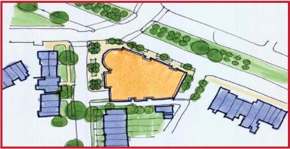
Potomac Ave Plan

(Plan view)

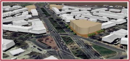
Potomac Ave Massing

(Massing perspective)

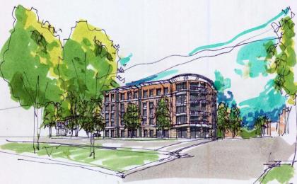
Potomac Ave Sketch

(Concept sketch)

A couple of points stand out.  First, when combined with the reconfiguration of the intersection’s traffic flow, buildings fronting on the new square ought to see more foot traffic – at a very least, the sidewalks they front on should be far more attractive to pedestrians walking either around the square or passing through it.

Second, the current Metro plaza, as mentioned above, would then be the one missing part of the streetwall enclosing this square.  Given that the station is such a focus for foot traffic, this is fine – but one potential benefit is that a taller structure on the 1401 site is directly in the line of sight of Metro patrons coming out of the station’s escalator well.

All together, such a project could be the keystone in the arch for this public space.  As of right now, I’m unaware of any specific plans for the site.  I’ll just enjoy my pizza until then.

But seriously, if this site does get developed soon, you gotta keep the pizza.

Links – Mono…D’OH!

With apologies to Lyle Lanley, it’s worth reporting that Disney’s genuine, bonafide, electrified, six car monorail! crashed.  Is there a chance the track could bend?

The Transport Politic notes the damage this kind of fantasy has on useful transit advocacy.   The Simpsons really does the same thing, when you think about it.

But the fact that more Americans have probably ridden the Walt Disney monorail systems than have chosen to take advantage of their local transit offerings is problematic. That’s because Disney presents a space-age vision for what public transportation should be, and it’s that fantasy that many Americans want in their trains and buses, not the mundane services like light rail and buses that most communities can actually implement. Meanwhile, Disney can offer the convenience of rapid transit in a safe, well-monitored environment, something difficult to do day-in, day-out in a real city.

The most damaging effect of the Disney monorail is the pervasive idea among virtually everyone other than transportation people that it represents the ultimate in transit technology. That’s why cries for “monorails!” come up at every turn when communities consider new transportation systems, even though monorails are consistently more expensive and less reliable than their two-track counterparts. It’s a mystery why people find the idea of the single, elevated track so exciting, but Disney’s example may be one explanation.

That Simpsons episode looks more and more prescient.  “…but Main Street’s still all cracked and broken!”

Avent vs. Glaeser. Ryan Avent takes Ed Glaeser’s recent Op-Ed on high speed rail to task over at Streetsblog.

Glaeser is correct that a good place to begin addressing our transportation failures is by pricing congested highway and air routes more effectively.

But we have every indication that doing so would significantly increase demand for rail services, while also raising tens of billions of dollars every year that could be used to construct a rail system that would be cleaner and faster than driving or flying. Contra Glaeser, pricing our existing infrastructure would make it painfully clear just how badly we need an effective intercity rail system.

In environmental and economic terms, the case for major investment in high-speed rail is quite strong. Unfortunately, wisdom seems to take wing whenever economists start writing about public spending.

Indeed.  Others take the social aspects of Glaeser’s proposition.  Any way you slice it, it’s pretty clear that Glaeser’s pop economics doesn’t do much in persuading the transportation blogosphere.

NIMBY’s Aren’t Environmentalists. The East Bay Express has a great piece on the role of cities and density in the environmentalism.  It’s a lengthy piece, but well worth the read.   The article makes several key points about how conventional thinking about managing urban growth, even with explicit intentions to be environmentally friendly, or to be affordable, often hurts the overall outcome.   Most importantly, the fight against density in developed, transit accessible areas is a major impediment to sustainable urbanism.

When put into a DC context, the article raises several key points about building heights.

Much of the heated debate over the plan has been about tall buildings. After eighteen months of meetings, a city-sponsored committee recommended that the council allow four 100-foot-tall buildings, and four that are 120 feet tall in the downtown area. However, the city’s planning commission, which is more development friendly, came up with its own plan that would allow six 120-foot-tall buildings, and four that are 180 feet tall — as tall as the existing Wells Fargo building, the city’s tallest. Both plans would also allow most new buildings to be built at a maximum height of 85 feet. The council appears to be leaning toward approving the denser plan, which some critics decry as “the Manhattanization of Berkeley.”

Hmmmm.  Where have I heard those arguments before?

In truth, the fight over building heights is misdirected. Tall buildings are unlikely to be built in Berkeley anytime soon because they’re too expensive to construct. The real difference between the two plans is that the less dense one will probably result in no tall buildings, while the other will probably produce four. The reason is that developers prefer buildings that are less than 75 feet tall or greater than 180 feet, but not in between. So any plan that calls for 100-foot- or 120-foot-tall buildings is unrealistic.

Why? In buildings that are less than 75 feet tall, developers can use wood framing, which tends to be relatively inexpensive. But above that height, fire-safety codes require them to build with reinforced concrete or steel, which costs a lot more. As a result, developers can’t make a tall building profitable unless it’s at least 180 feet in height (seventeen stories). Anything shorter than that means that the developer won’t generate enough money from selling condos or renting apartments to pay for the high costs of erecting the building in the first place.

Of course, with land values as high as those in Downtown DC, you can easily justify going as high as possible – even though those heights fall within that ‘unrealistic’ zone of 100-120 foot tall structures.

Oakland could achieve plenty of density with 75-foot-tall housing developments, Pyatok argued. Assuming that such buildings can house about 150 people per square acre of buildable space, that works out to about 96,000 residents per square mile. As a reference, Manhattan is home to about 65,000 people per square mile. “It’s just a misunderstanding to think that you have to have high-rises to get high density,” said Pyatok, who also has been studying the potential growth of Upper Broadway with a group of graduate students. “I really think that a 75-foot height limit throughout a great deal of downtown could create a lot of density.”

This is more or less the situation we see in a lot of DC, at least with regard to the height limit (and therefore upper cap on density).  What’s missing, of course, is that most of DC’s areas built to max height are office districts, not residential ones.  Fear not, however – there are solutions to this, as well:

Oakland, he believes, should limit skyscrapers to Broadway, near the 12th Street and 19th Street BART stations. Or, he said, the city should take a hard look at what San Francisco and other cities have done. San Francisco limits both building density and height, but allows property owners to buy and sell development rights to construct skyscrapers. So if you’re a property owner and you do not intend to build a high-rise, then you can sell the space above your building to another developer, who then can add it to his or her property and build taller. As a result, San Francisco has been able to protect historic buildings while controlling land values and spurring growth.

For DC, a transfer of development rights program to encourage the sale of density rights from areas worth protecting (whether they be existing rowhouse neighborhoods or the height-capped and very high value downtown) and transferring them to a designated receiving zone could be a framework to grow the city around in the future.  Designating a few receiving areas, such as Poplar Point, would allow some taller buildings (perhaps eclipsing that dead zone where building up doesn’t make economic sense) to give DC a high rise district similar to what we see in Rosslyn, Silver Spring, and Bethesda.  Doing so with a TDR program would continue to encourage infill development and densification within the city while still allowing an outlet for development pressures in areas of the city we wish to protect.

With any such plan, of couse, the devil’s in the details – but it’s certainly worth considering, in my mind.

A New Square for Potomac Ave

July’s issue of the Hill Rag contains some interesting tidbits in their ANC 6B beat report about a potential reconfiguration of the traffic patterns at the intersection of Potomac and Pennsylvania Avenues in Southeast Capitol Hill.  Talks of reconfiguring Penn. Ave’s course through Capitol Hill seems to be in the news a lot these days, with Greater Greater Washington talking about the process going on just up the road around Eastern Market.

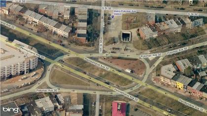
Potomac Ave

(Bing Maps aerial oblique of the intersection.)

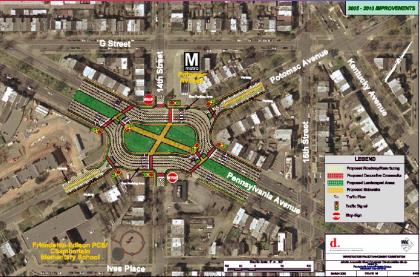
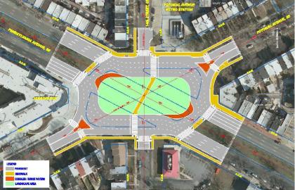
DDOT’s proposal for the intersection is to merge the three existing traffic islands in the current ‘square’ while re-routing Pennsylvania’s traffic flow around the perimeter of the square.  DDOT’s presentation showed two potential plans for remaking the intersection – one from the Middle Anacostia Crossings plan, and their preferred alternative.

Potomac Ave MAC plan

(MAC Plan)

Potomac Ave Preferred Alt

(Preferred Alternative)

The one key difference between the initial MAC plan from 2005 and the preferred alternative is the elimination of the east-west crosswalk through the square.  The initial plan called for pedestrians to be able to access the square while standing in the median of Pennsylvania Avenue.  This element was dropped from the preferred alternative.

The Hill Rag’s reporting made it seem that the ANC commissioners did not take kindly to the options presented:

While the commissioners and audience members didn’t seem to particularly enjoy the current layout, DDOT’s plan was universally panned for a number of reasons. One woman who lives near the intersection said the plan doesn’t go far enough to increase pedestrian safety, and she urged DDOT to consider installing a traffic camera in the area to cut down on driving violations. Another woman said that creating a traffic circle would obstruct the view of the Capitol building for drivers heading west on Pennsylvania Avenue.

Commissioner Carol Green said that the plan was unreasonable because it would prevent pedestrians from directly crossing Pennsylvania Avenue at the intersection.

“There’s going to have to be some way for them to cross without going a block out of their way, because that’s essentially what you’re asking them to do right here,” she said. “I can tell you for sure, they’re not going to do it.”

Commissioners voiced frustration when it became clear that the DDOT proposal was the only plan on the table right now. If the upcoming public comment period reveals that the community mainly objects to the plan, the entire planning process would need to start over and the project would be delayed for several years.

I’m not sure any of these criticims have any merit. Taking them in order:

Traffic cameras. These kinds of programatic elements are kind of beside the point when discussing major design decisions.  By forcing Penn Ave traffic to make a turn, it will naturally slow things down.  Traffic law enforcement strategies are a separate issue.

Obstructed views for drivers. Give me a freaking break.  Drivers will have a completely unobstructed view of the Capitol Dome on the blocks preceeding and following this square on their way into town.  By reconfiguring the public space here, may pedestrians might get some of that view, too.

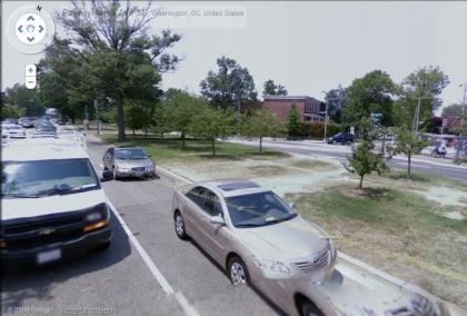
Prevention of directly crossing Pennsylvania. I have no idea what Carol Green is talking about here.  I live nearby and have crossed this intersection many times, and either of the proposed changes would make it far easier to get across Pennsylvania.   The new square will make it much easier to traverse up and down 14th street, as you now only have to cross two streets to do so, whereas before you have to cross four.  Furthermore, there’s more than enough evidence on the ground of  ‘choice paths’ worn into the Pennsylvania median strip from jaywalkers cutting directly across:

Potomac Ave streetview

(Image from Google Maps Streetview)

Looking at either plan, I can’t see any scenario in which a pedestrian crossing Pennsylvania will have to go a block out of their way.  Perhaps Comissioner Green was referring to people travelling along Pennsylvania rather than trying to cross it.  It’s true that these Pedestrians will now have to walk a short distance around the square, but in that instance they wouldn’t save any time by walking in the street – as they would simply be walking through traffic, rather than the current practice of jaywalking to get across.  Even so, a few rough calculations from the aerial maps show that a Pedestrian traveling on the southern side of Pennsylvania Ave would have to walk an extra 70 feet (~400 ft vs. ~330 ft) to cross from one side of the square to the other. When presented with reasonable alternatives, as we see from various other squares and circles in DC, pedestrians will take them.

All things considered, I fail to see what the commissioners are concerned about.  This concept takes the current arrangment of public space and prioritizes pedestrians over cars.  I’d prefer to see the iteration from the MAC plan, making this square a more accessible place with four crosswalks rather than two, but the general concept is solid.  Jaywalking at this intersection is rampant.  It’s both a safety hazard and an indicator of a poorly designed space.

On the other hand, the opportunity to vastly improve the safety of this intersection, as well as provide a new public space for the neighborhood is too great to simply dismiss.

Cake Loves Parking

GGW’s links thread brought my attention to U Street high-end cupcake retailer CakeLove’s foray into the world of urban planning.  CakeLove founder Warren Brown originally wrote about the issue in a blog post back in 2006:

Tear down the Reeves Center, please. Give the Mid-City Business District community what it wants and needs: PARKING.

Not having enough parking interferes with my business. Parking is the major restraint on the growth of my business. Everyday people from Virginia, Maryland, and DC don’t come to CakeLove or Love Café because they’re certain there parking won’t be available. Most of the parking around CakeLove and Love Café is off-street and it fills up fairly quickly. The solution is to eliminate the perception that there is inadequate parking. Only then will people change their attitude that access to retail, nightlife, dining and services in this neighborhood is real.

How do we get there? Build a parking garage. Tear down the Reeves center at 14th & U St. NW and build a new anchor – a municipal parking structure that’ll hold 1,500 cars. Give this community what it wants and needs: PARKING. The Reeves center fulfilled its mission as an anchor for re-development on the U Street corridor. It signaled the direction for change and now we’ve turned a new corner. Development is fully on track and the needs for that space and the community are different. What the current and future businesses and residents need more than a partially occupied municipal center with closed and redundant storefronts is a lot of parking spaces. The Reeves center is obsolete.

Granted, this is an old thought, but thanks to the magic of the internet tubes, it’s suddenly back in the forefront.  CakeLove’s driving directions encourage folks to double park when visiting.  Warren had a new post on the issue recently:

Hey – thanks for the comments in about parking – although people are arguing for less parking and less drivers. But I don’t think that the Metro system is one of the best in the world. It closes early, it’s slow, it’s not the safest in the world, and it doesn’t get you everywhere. I have to go to National Harbor today. Metro doesn’t go there and if I did a combo of walk, train, and bus, it’ll take three to four times as long in one direction. And hardly anyone takes metro there anyway.
I understand the argument for less drivers, it would be great to have less pollution from drivers, but driving is a fact of life of course and putting the cars someplace is something urban planners have to contend with if they want to support local business. No storefront that I know of in any community can survive without driving customers.

I appreciate Warren’s enthusiasm, but like many small business owners, I’m afraid his policy recommendations are misplaced.  Let’s amalgamate them and go one by one:

  • The Reeves Center is obsolete – The Reeves Center certainly wasn’t the cause of U Street’s revival, but it’s also not obsolete.  It does provide a nice office component to an area that doesn’t have much of that land use.  Areas like Dupont Circle are so vibrant because of their healthy mix of retail, residential, and office uses.  U Street doesn’t have that, and a little office in the area isn’t a bad thing.  It’s not the DC Goverment employees’ fault that they’re not going to eat gourmet cupcakes for lunch everyday.Also, from purely a functionality standpoint, the Reeves Center isn’t an architectural masterpiece, but it is a perfectly functional building.  Tearing it down would be a mistake.
  • And he wants to replace it with a parking lot? – First things first – No, U Street does not need a municipal parking structure.  Second, does Warren realize exactly what he’s asking for?  A 1,500 space garage is HUGE.  take a look at the WMATA garage at Glenmont.  The entirety of WMATA’s Glenmont parking supply is just over 1,700 spaces, most of which are in this garage.  You’re not going to fit that on the Reeves Center site.  Nor would you want to – I’ll take an active, occupied building over a parking garage any day of the week – even if it’s poorly designed – and especially if it’s sitting on one of DC’s most prominent intersections.
  • Asking for “more parking” is useless unless you talk price – One of the key points of Shoup’s parking manifesto is that you can’t address supply while ignoring demand and price.  All too often, store owners in retail environments push for lots of cheap parking, trying to compete with malls and suburban areas at their own game.  Instead (since urban areas can’t beat malls in terms of parking supply), the spaces you do have are underpriced and thus overused.  That’s the real issue.  Unfortunately, there are plenty of anecdotal cases of main streets providing lots of free on street parking with the idea that it will spur shoppers to visit, only to find out that those spaces are hogged by people with long term parking needs who are seeking cheap spaces to park – and that many of those parkers are actually employees of the stores that demanded the cheap, underpriced parking to begin with.
  • Disparaging Metro isn’t going to help, either – The comparative advantage that U Street does have, however, is two-fold – U Street is a uniquely urban area, and it’s very well served by transit.  It’s got a great surrounding residential neighborhood, and is also a draw for folks from all around via transit.  If those conditions don’t support gourmet baked goods, so be it.  That isn’t to say that parking policies are perfect – far from it – but they also aren’t the core of the issue, either.As an aside – Warren’s complaints about Metro’s lack of service to National Harbor are an idictment of that development, not the transit system.  One of those things substantially predates the other.  As far as hours of service go, I’m not sure what bearing that has on retail viability on U Street, since Metro is in operating for several hours before CakeLove opens and remains in operation well after it closes.

Anyway, I don’t mean to pile on, but this is a great example of how we could use true performance parking along many of these retail corridors.  Following Dr. Shoup’s model, variable pricing of spaces that ensures an 85% occupancy rate would keep parking at the cheapest possible price while also ensuring that no matter what, a potential patron arriving by car will be able to easily find a parking space.

It’s vital that we address Warren’s concerns, as creative retailers like him are a great asset for the city.  However, it’s equally important that those concerns are addressed with sound theory.  Following Warren’s suggestions literally (tearing down the Reeves Center and replacing it with a municipal parking garage) would induce more traffic, congestion, and pollution in the city; would severly harm the urban form of the area; would reduce the density of people using the 14th and U space at a time when that area has that ‘critical mass’ of people; and as we’ve seen with the grossly underutilized DC USA parking complex, the parking is probably not even be needed.

There are no one size fits all solutions in urban areas.  More parking is not the answer here.

Metro Fantasies – now with pictures

Following up on my previous comments about Metro expansion and a new Yellow line, I wanted to add some graphical representation of these ideas.

First, the current Metro system:


View DC Metro in a larger map

My plan includes the Silver line as currently planned and under construction, as well as my conception of the new Blue line (shown in teal) as well as a separated Yellow line (shown in Goldenrod), with separation from both the Green like through DC and from the Blue line through Arlington and Alexandria.  The new lines only are here:


View DC Metro Expansion in a larger map

Combine both the current system and the new plans, and you get this:


View Combined Metro Map in a larger map

Old tracks are in blue, new tracks in yellow.

Obviously, these maps have no stations (yet).  It’s safe to assume that where two lines cross, you’d want to have some sort of a transfer station there.  With new lines crossing (thinking specifically of the intersection of North Capitol and H St), you could have a brand new Metro Center-esque station, linked by tunnel to the current Red line stop at Union Station.

The purpose of putting these lines on these streets is merely to define the corridors and ensure some feasiblity in terms of potential rights of way and station areas, but they shouldn’t be considered concrete decisions.

Adding to Metro’s Core Capacity

Greater Greater Washington’s always had some great fantasy transit discussions – whether talking about the New Blue line, more fantastic visions, or even the multimodal vision for Baltimore and DC.  Over the last few days, the fantasy discussions have started again.  Though these are not always the most realistic discussions, they’re a great starting point for larger discussions about the role of transit in the transportation system in the city, and more importantly they discuss what kind of city we want to have.

This past week’s discussions have focused on the idea of a new Yellow line – originally posted here, along with my response.   The entire premise of separating the Yellow line from the Green line (at least as I understood it) was to increase the maximum capacity of both lines – the same premise behind the idea of separating the Orange and Blue lines.  That way, both colored lines would have full capacity for their entire length.  Doing such a project would also have ancillary benefits, such as adding redundancy to the system with multiple tracks on fairly similar routes, as well as opening up new areas to Metro service (such as adding Metro service to H Street NE with the New Blue line).  Each of these ideas is worthwhile, though slow to implement.  Given the facts that Metro is already straining to handle the crowds along the Orange line though the RBC, focusing on this kind of long term planning is important.  Building new subway lines will take a long time, and with Metro expected to reach capacity sometime between 2025 and 2030, starting the planning process now is vitally important (i.e. Metro was recommended as the preferred alternative for the Dulles Corridor in a 1997 report – the full line is now set to open in 2016 – nearly 20 years after the fact).

With that in mind, proposals that involve a great deal of capital construction must have a long term plan behind them to justify the investment.  The idea of separating the Blue and Orange lines is a good start.  Having a longer term plan to separate the Green and Yellow lines is also a good idea – even better would be to combine those efforts sowe have a nice 50 year map to follow for Metro’s development over time.

The lack of this kind of focus and long term vision troubles me with GGW’s latest series of posts about adding new trackwork in downtown DC.  The premise is a simple question: is there a simpler and cheaper way to add core capacity to Metro without building the entire New Blue line?

How about separating the Yellow Line instead? The Yellow Line plan Dave Murphy suggested last week, and some of your comments, suggest a possibility. If we separate the Yellow and Green lines in DC, then Metro could put many more trains over the 14th Street bridge. According to Metro planners, this option would involve building a shorter subway tunnel from the 14th Street bridge to the Convention Center along 9th Street.

While the tunnel at Rosslyn is already at its capacity, the 14th Street bridge isn’t, because all its trains must merge with Green Line trains from Branch Avenue. Metro can squeeze a few more Yellow Trains in if they reduce Blue trains, but not that many. If the trains didn’t have to compete with the Green Line, the 14th Street bridge could carry many more trains from Virginia.

The second iteration of the idea also generated a great deal of discussion:

If we could run more trains over the 14th Street bridge, where would they go in Virginia? I can see two possibilities: convert the Arlington Cemetery segment to a shuttle train, or add connections to route the Silver Line over that segment as well as the Blue Line.

Both of these ideas are intruiging from an academic perspective, but completely lose sight of why you’re adding core capacity in the first place.

Remembering that the whole point of the New Blue line is to separate it from the Orange line tracks it shares through DC, the reason it gets brought up first is due to the popularity of the Orange line in Northern Virginia.  This GGW idea is an attempt to solve that same problem by essentially starting on a new Yellow line.  You’re essentially building half a subway, except that you’re building the New Yellow line first when the Blue line is the obvious choice.

If you’re going to put shovels into the ground, you might as well make sure that the plans have long term significance.  Metro’s genius is that it was concieved as an entire 100 mile system.  Even so, it functioned well before the full system was complete.

WMATA should take the same step here.  If you want to add new capacity to downtown DC by building half of a new subway, just start building the new Blue line – and do it in phases.  The first phase (say, from Rosslyn to the Connecticut Ave station) would accomplish the same thing – freeing up core capacity on the Orange (and Silver) line, as well as delivering Blue line riders to the core of downtown.   However, unlike the 9th street proposal, the Blue line would be readily expandable at a later date, much like how the Mid City portion of the Green line was completed in phases (with U Street opening in 1991, while Columbia Heights didn’t open until 1999).   Ideally, you’d like to do it in one fell swoop, but the entire premise of this idea is that the funds to do such a project aren’t there.  So let’s at least plan it with expansion in mind.

With that said, the idea of a new Yellow line isn’t a bad one at all, even if the timing isn’t quite right.  However, using 9th street doesn’t make a lot of sense when you already have lines along 7th and 12 streets downtown, and along 14th street in Columbia Heights.  The alignment proposed in the original post makes a lot more sense when viewed with a long-term lens.  A 9th street alignment would indeed be redundant, but almost too redundant – it wouldn’t open up any more area to Metro service, such as the transit poor Washington Hospital Center.  A North Capitol/Georgia Ave route would provide redundancy for both the eastern Red line, the whole of the Green line, and open up a major commercial street to Metro.  This line could also be phased in over time, initially operating as just a partial segment.

As Burnham said, “make no little plans.”  If you’re looking for incremental physical improvements, I’d opt to ensure that they’re part of a larger plan.  The final result will be far better for it.

Links – higher, faster, more conservative…

My Firefox browser is full of open tabs with sites I’ve been meaning to link to over the past few days, but haven’t had the chance – so here goes.

Higher (?) – Last week, there was an interesting back and forth between several DC bloggers over DC’s height limit.  BeyondDC and Ryan Avent had an interesting exchange, followed by Matt Yglesias chiming in, as well as the Tsarchitect citing previous posts about the very same topic – since it seems to pop up (heh heh) every few months or so.

My personal view sort of splits all of those presented.  I think the height limit has served DC well by ensuring that development achieves full coverage – downtown DC is virtually devoid of surface parking lots, something that’s rather uncommon for American cities.   At the same time, it’s not too hard to envision a future where all of DC’s developable lots are taken, making it difficult to both continue to grow AND maintain the character of some great existing rowhouse neighborhoods AND focus development around urban transit hubs.

I think an interesting solution might be to create a designated high rise district within DC, where there is no height limit.  Poplar Point might serve that role well – like London’s Canary Wharf, such an area would be a place to focus taller development, perhaps accompanied by a transfer of development rights programs from the high demand but height-restricted areas in downtown.  Of course, such a plan would necessarily require a much stronger effort in building up transportation infrastructure as well, but I think building heights there on the same scale as Rosslyn would preserve the form of DC’s monumental core, provide an area to grow the tax base, and bring some much needed amenities across the Anacostia.

Faster (?) – Several good reads on high speed rail planning:

I can’t argue with these points – upping the speed of these trains to 110 mph service isn’t really high speed by any definition.  The notion that travel time should be more important than top speed is actually correct, but of course the two concepts are linked very closely together.

At the same time, even the upgrades that allow for 110 mph service – things like grade separation, signalling systems, etc. – will offer tremendous benefits to current rail service and can also be applied to future high speed service.  Those grade separations may not work for true 220 mph TGV-like service, but they could very well take an Acela-like train, operating with a slightly slower top end, but still very fast.

In short, there’s no reason to not pursue both incremental improvements and also the ‘big’ plan.  However, what both of these efforts need is a unifying national strategic plan.

Transportation isn’t conservative or liberal – Two interesting items on the roles of conservatives in planning and funding transportation.  PBS has a long interview with Rep. John Mica (R-FL) on the need for transportation investments:

BLUEPRINT AMERICA: You are a Republican – and you support transportation and infrastructure spending?

REP. MICA: Well, I tell you though, if you’re on the Transportation Committee long enough, even if you’re a fiscal conservative, which I consider myself to be, you quickly see the benefits of transportation investment. Simply, I became a mass transit fan because it’s so much more cost effective than building a highway. Also, it’s good for energy, it’s good for the environment – and that’s why I like it.

BLUEPRINT AMERICA: If anything, you’d say that your time in Congress and on the Transportation Committee has brought you around to these ideas?

REP. MICA: Yes. And, seeing the cost of one person in one car. The cost for construction. The cost for the environment. The cost for energy. You can pretty quickly be convinced that there’s got to be a more cost effective way. It’s going to take a little time, but we have to have good projects, they have to make sense – whether it’s high-speed rail or commuter rail or light rail. We got to have some alternatives helping people – even in the rural areas – to get around.

Good stuff.  Always good to see these kinds of viewpoints from Republicans, as most of these infrastructure decisions really ought to (and have in the past) transcended petty partisan differences.

Mica also raised some great points about the need to reform the process of building infrastructure in the US:

REP. MICA: The second part is speeding up the process. Most projects that the federal government is involved with take an inordinate amount of time for approvals, and they cost much more because there are so many delays and hoops that people have to go through.

I offer what I call the Mica 437-day process plan, which is the number of days it took to replace the bridge that collapsed over the Mississippi River in Minneapolis. Rather than the seven or eight years it takes complete any other bridge, which would be the normal time frame.

BLUEPRINT AMERICA: And why did it just take 437-days to complete?

MICA: It was done on an expedited approval basis, which I think you could do with most projects that don’t change the basic footprint of the infrastructure that you’re rebuilding.

I was born and raised in Minneapolis – and was in the city during the immediate aftermath of the I-35W collapse.  When I went back to visit my family for the holidays, it was simply amazing to see the bridge complete and open so quickly.  I’d stress Mica’s point further – we need to reform the process in many ways, but the time delay for using federal funds is a high price to pay.

Along the lines of conservative stances on transportation, Infrastructurist has a nice interview up making the conservative case for public transportation.

If there’s one thing to take away from this, it’s that all forms of transportation are heavily subsidized.

Fantasies

Dave at Imagine DC (and also GGW) put up a nice concept of a separated Yellow line through the core of DC.  Separating the Blue line has been the most popular suggestion, and was originally among WMATA’s official plans, but the idea of separating the Yellow line is relatively new.   Still, amongst extensive discussion in the comments from previous fantasy maps, the idea has come up before – my name is somewhere in those comment threads.

Given the focus that Monday’s accident has put on redundancies in the transit system, it’s fitting to consider the idea.  However, it’s important not to lose sight of the reasons for such plans and expansions in the first place.  With that in mind, I’d propose a few key principles to consider for any metro expansion plan:

  • Separation of the current interlined portions of track.   The proposals to separate the Blue and Yellow lines certainly do this, and for good reason.  The ‘tail’ sections of each line are limited by the capacity of the shared track at the core.  Furthermore, the complexities of switching so many trains on and off the same line only adds to potential delays.  Separating these lines would offer wide ranging benefits to other lines in terms of increased service frequencies.
  • Plan the entire system now.  By ‘now’ I don’t mean today, but if plans are drawn up to implement this kind of expansion, it is vitally important that the lines are planned together.  The fact that all 100+ miles of Metro were planned as a coherent system is what makes it such a useful system today, rather than a hodgepodge of individual lines.  If you look at the poor connections between Baltimore’s light rail and subway, you’ll see precisely what you wish to avoid.  That means planning to separate the Blue & Orange lines, the Yellow & Green lines, and the VA portions of Yellow & Blue at roughly the same time.  Doing so, like the original system, will allow for transfers to be built in and will make for a much better overall system.  Begin with the end in mind.
  • Learn from Metro’s past. Metro’s hybrid nature as both an urban subway and a suburban commuter rail system makes for some interesting compromises in terms of system design.  Given that the newer portions would entail track mostly in urban areas, it’s important to apply the lessons of Downtown DC, the Rosslyn-Ballston corridor, and others.  This is about urban transit, not park and ride stations.
  • Coordinate plans with other modes. Metro expansion should focus on the core because that’s where it’s most useful and can justify the cost.  Ideas like extending the Orange line to Centreville, or the Green line to BWI miss the opportunity to have a newly beefed up regional rail system operating in place of MARC and VRE trains.  Ideally, such Metro expansion plans would be coupled with a transformation of the commuter rail services into a more S-Bahn like system.  In the other (more local) direction, coordination with streetcar planning is also vital.

Speaking in terms of broad corridors, Dave’s plan for the Yellow line is spot on.  I think he’s got too many stations for a heavy rail line, but the general corridor is correct – the line would use the same bridge over the Potomac, then go underground and follow the Maryland Ave right of way, linking to L’Enfant Plaza with a new platform for the station complex.  The line would cross the Mall, then travel north under North Capitol, including a station at H street – which would also be part of the station with the new Blue line – also connecting to the current Union Station stop (hence the importance of planning these lines at the same time).  The line should go up to the Washington Hospital Center, serving that major employment center, then sliding to the west somehow to turn northward again under Georgia Ave.  After reaching Silver Spring, the line can either end there, or continue north along US 29, as proposed by Sand Box John.

The Blue line has been discussed many times – I think the best alignment would be across town under M street, angling southward under New Jersey Avenue, and then continuing east under H street – ideally with transfers to the Red line at both Union Station and under Connecticut Ave, as well as a Green line transfer at the Convention Center and a transfer to the new Yellow line near the Union Station complex.

Separating the Blue and Yellow lines in Virginia is probably the easiest route to conceptualize – simply shooting the line outward under Columbia Pike is the most obvious choice, making the current line to Alexandria one ‘color’ with multiple spurs – one to Huntington and one to Franconia-Springfield.