Category Archives: Transit

Assorted Portland tidbits

Portland Aerial Tram - image from joseph readdy on flickr

Portland Aerial Tram - image from joseph readdy on flickr

Ah, Portland.  Metropolis of planning, bicycling, and all things creative.  A couple of things have piled up in my open tabs or in my reader.

Portland hasn’t seen huge shifts in mode share (as noted here previously – hat tip to Jarrett Walker here and here), despite large investments in light rail, streetcars, and even an aerial tram.

Picture perfect? Aaron Renn penned an op-ed piece for the Oregonian, providing a little perspective about Portland’s image as the perfect planning city.  Renn doesn’t question Portland’s overall quality, just if the reputation is deserved or not – if the praise matches the performance.

Renn follows his op-ed with a blog post, delving deeper into the stats, comparing hip and cool Portland to the decidedly less cool Indianapolis.

I note as a positive that Portland was clearly ahead of other similar sized cities in understanding the importance of density, transit, bike lanes, etc. But more importantly, that the “Portland model” had a wide influence in America. Perhaps Portland has had a greater influence on America’s urban environments than any other city its relative size in history. That’s an amazing accomplishment if you think about it. And what’s more, that influence has been a good thing.Naturally, they don’t need me to just tell them “It’s all good”. So on the areas for development side I noted their underperforming economy. It’s not so much that Portland is particularly suffering in this recession, though it is, or that it is a failure in an absolute sense, which it is not. No, rather I look at it like diving. There are two aspects: execution and degree of difficulty. Portland has very low degree of difficulty, so we would expect it to perform much better.

Renn’s takeaway is that policy can only do so much.  That’s true, to some extent – policy sets the rules in place, and the dynamics of the city have to do the rest.  There are also factors well beyond any city’s (or any region’s) control.

Like any data set, it’s wise to look at the limitations of the data.

Putting the emphasis back on Portland’s transportation policies, Jarrett Walker looks at car ownership rates in cities across the US – and Portland doesn’t even crack the top 50.  (DC checks in at #4, with a 36.93% of households owning no cars – jurisdictions 1, 2, and 3 are all in Metropolitan NYC).  Walker identifies three criteria that correlate with high rates of non-auto households – age of the city’s fabric (with an anecdotal correlation to density and design), poverty, and presence of major universities.

So here’s the question:  How long will it take for a city that lacks age, poverty, or dominant universities to achieve the kind of low car ownership that these 50 demonstrate?  How soon, for example, will a city be able to create a combination of density, design, and mixture of uses that yields the same performance as an old city that naturally has those features?

Portland is probably the most promising such city in the US, and it’s not on the list.  Only 14% of households there don’t have a car, so it’s probably well down in the second 50.  Like many cities, Portland has been doing everything it can to build a dense mixed-use urban environment.  It’s the sort of city that convinces the Safeway supermarket chain to rebuild their store with townhouses and residential towers on top.  But while people are moving into the inner city, they don’t seem to be selling their cars when they do, nor do they seem to be going to work by transit.

For me, the takeaway from this is the long lag time and staying power of transportation infrastructure.  Even as older cities, built around walking and transit, have decayed, they remain more car-less than their fellow cities built with the car, to say nothing of cities built for the car.

I recall attending a lecture in grad school (and I cannot for the life of me remember who exactly gave it), noting the staying power of our street networks and other infrastructure patterns.  In short, land use changes on a big, extensive scale take a long time to happen.  Walker continues:

How much are zero-car households constrained by overly abundant residential parking?  It’s still hard to sell a modern tower unit without a parking space included, even though there are many such units in pre-car cities like Manhattan and San Francisco, and many are quite desirable.  What would it take to replicate that desirability in new inner cities like Portland’s?  Couldn’t it be done at least in the name of affordable housing?

All good questions to ask, even if only asked rhetorically.

Finally, some pretty pictures. Free Association Design has some great planning graphics from Portland.  Fun stuff to look at.

Portland's public realm.  Image from the City of Portland

Portland's public realm. Image from the City of Portland

Portland's zoning code, graphically depicted w/ height limits and mixed uses (red shading).

Portland's zoning code, graphically depicted w/ height limits and mixed uses (red shading).

Good stuff.

Cost-effectiveness

Streetcar tracks, H St NE - CC image from flickr

Streetcar tracks, H St NE - CC image from flickr

Over the past couple of days, there have been lots of reactions to the DOT’s decision to lessen the importance of their cost-effectiveness measures in decisions on new transit starts funding (TTP, Yglesias, TNR, TOW, Streetsblog), almost all of them positive. There are, however, some key points to consider.  With the emphasis on livability as opposed to cost-effectiveness, the question will now be about measuring that livability.  Jarrett Walker notes:

Great news, perhaps, but I look forward to seeing how FTA is going to turn something as subjective as livability into a quantifiable measure that can be used to score projects, particularly since the payoffs lie in development that a proposed transit line might be expected to trigger, but that usually isn’t a sure thing at the point when you’re deciding to fund the line.  And of course, travel time does still matter.

Measurement is indeed the key.  Part of the problem of the Bush Administration’s emphasis on the CEI was an expansive definition of costs and a rather narrow definition of ‘effectiveness.’

The other problem is one that Donald Shoup talks about extensively in his book, The High Cost of Free Parking.  Namely, often imprecise data points are given undue precision in a bias towards quantifiable results and numbers – precision and accuracy are two different things, and it is important not to conflate them:

HOW FAR IS IT from San Diego to San Francisco? An estimate of 632.125 miles is precise—but not accurate. An estimate of somewhere between 400 and 500 miles is less precise but more accurate because the correct answer is 460 miles. Nevertheless, if you had no idea how far it is from San Diego to San Francisco, whom would you believe: someone who confidently says 632.125 miles, or someone who tentatively says somewhere between 400 and 500 miles? Probably the first, because precision implies certainty.

This doesn’t disprove Jarrett’s point – there are still metrics that can be used for more qualitative factors – but the larger issue here is a move away from false precision and towards outcomes that are more accurate – outcomes that better reflect the true (qualitative and quantitative) nature of cities.

With that in mind, it’s interesting to read some reactions published in the National Journal (h/t Planetizen).

Anthony Shorris: The new approach laid out by Secretary Lahood should force a re-thinking of all of our evaluative tools — cost-benefit analysis, alternatives analysis, environmental impact statements — with an eye toward re-balancing them away from an excessive reliance on only those measures that can be readily quantified.  This re-thinking should be inter-departmental (including other agencies and OMB) and inter-disciplinary (including the perspectives of urban planners and designers as well as economists).  One thing the financial crash should have taught us is that there are limitations to even the most seemingly sophisticated financial models, and that apparently crisp spreadsheets are no substitute for the prudent exercise of judgment that the American people have a right to expect of their leaders.

William Millar, APTA: With the action taken by DOT to consider all the factors required by law, transit projects can now be looked at from a holistic perspective. By judging a project on the multiple benefits it offers (i.e. mobility, economic development, environmental impact, land use improvements etc.), a well-rounded and more informed decision can be made. By removing the barrier that the Bush Administration implemented, the process is now in alignment with how it was originally intended to be.

Projects must still be cost effective and meet at least an overall medium rating in project justification and local financing. However, now, instead of a narrow prism through which to judge a project, a wider lens will offer a larger perspective. It should encourage innovative projects to be proposed and funded.

Subway architecture – world tour

Several sources have linked to a great photo compilation from design boom on avant garde subway station architecture from around the world.   The images come from:

Some of the stations are quite striking – and no, DC did not make the list.

The question it raises for me is the value in having a coherent design language for the system – providing ease of use for passengers – and sparking visual interest and making great spaces.  DC’s vaulted stations fit into its federal, monumental role quite nicely, but the uniformity of the system (despite the small differences and details) can also be monotonous and dull.

In the event that more underground Metro stations are added within the District (perhaps with the New Blue line, or other core expansions), it’s interesting to think about new station architecture that would maintain the same design principles of the current system (volume, open train rooms, common materials – concrete, brass, red tile, etc, indirect lighting) while also allowing some variability that could provide unique identification for certain stations without sacrificing design unity.

Stockholm Metro Escaltors - from flickr

Stockholm Metro Escalators - CC image from flickr

Stockholm Metro - from flickr

Stockholm Metro - CC image from flickr

Stockholm Metro - from flickr

Stockholm Metro - CC image from flickr

Stockholm Metro - from flickr

Stockholm Metro - CC image from flickr

Stockholm Metro - CC image from flickr

Stockholm Metro - CC image from flickr

Many of Stockholm’s stations, for example, use the look of exposed rock tunnels (a look considered for DC by Harry Weese, incidentally – to show the differences in construction methods for the stations drilled into the rock, versus those crafted with cut-and-cover methods), providing unity between stations while still allowing for unique designs.

Perhaps future expansions to the Metro could swing more in the direction of unique station designs and public art installations.

Streetcars have arrived

Our first streetcars are here. DDOT’s facebook page has the pics.

Ruth Samuelson fears burnout!

Since late summer, the city has been buzzing about streetcar lines coming to Anacostia, H Street NE and possibly numerous other corridors across the city. Some people are thrilled. Others cry waste. But until Saturday, no D.C. streetcars were actually in America—they were in the Czech Republic, of all places.

I don’t know if Ruth has noticed, but the Europeans tend to build these things better than we do (at least right now).  Of course, it won’t always be that way – see United Streetcar.

Then today, news broke that the cars were here! Why this was news is kind of peculiar. Do people care when a new, updated version of the METRO car arrives?  A press release from the District Department of Transportation noted the length of the streetcars journey–4,200 miles. It detailed what kind of measures were taken—a “wax coating” was applied “over the external surface of the street car”—to prepare the streetcars for their voyage. It featured an enthusiastic quote from DDOT director Gabe Klein, suggesting that D.C. residents were just dying to see the vehicles up close and personal– as if they were the newest presidential pets.

I’ll fully admit that I’m far nerdier about this than most, but I am just dying to see these vehicles up close and personal.  And I do like riding in new Metro cars.  I’ll even throw in my two cents about their design.  I know I’m not the only one, either.

So, is this really newsworthy?  I don’t know.  But the beauty of this is how DDOT’s managed to use some social media to get the news out to a community that really wants to hear it and see the pictures.  Little things like this make a big difference.  Metro, for example, could use a little good publicity right now.  Positive waves!

Around the horn

Minneapolis

Back in my hometown, yesterday marked the first day of revenue service for the Northstar commuter rail line between Big Lake and downtown Minneapolis.  This is Minneapolis’ first heavy rail commuter line, which will look for a quick expansion to the originally planned terminus of St. Cloud, MN.

Yonah Freemark offers his assessment at The Transport Politic.

The $320 million would have been better spent on promoting transit that can be used round-the-clock by people who have a choice not to use cars — something that’s made virtually impossible by the design of Northstar’s schedule and stations. With several other peak-period-only commuter lines under consideration, however, Metro Transit will likely spend more on projects such as this before it decides to pull back.

One note – that capital cost number also includes the money to extend the Hiawatha Light Rail line from the previous downtown terminus at the Warehouse District to the new terminus at the new Target Field.  When all is said and done, that will be a great transit hub for the city, and considering that the project’s cost includes this LRT extension, the numbers look more favorable.

Service can always be increased at later dates.  Given the line’s terminus at the Minnesota Twins’ new stadium, I’m sure we’ll see ballgame service in the relatively near future.  Commenters also note that Minneapolis has a much stronger downtown employment core than other cities with new, struggling commuter lines.

MinnPost‘s excellent article (as per usual) from Steve Berg also notes the history of rail in the area:

“As far as I can tell, the Twin Cities probably had the largest commuter rail network in the U.S. to totally disappear,” said Aaron Isaacs, Minnesota’s foremost railroad historian. During the peak of local railroading in the late 19th and early 20th centuries, as many as 15 commuter lines spread outward from the two downtowns, most of them from St. Paul’s Union Depot or Minneapolis’ Great Northern and Milwaukee Road stations. By the mid 1880s, three competing railroads offered trains over three different routes every hour between the two downtowns, Isaacs said, 74 trains in all.

Commuter trains also ran on a dozen suburban routes:

• From downtown St. Paul to White Bear Lake, Lake Elmo, Stillwater, St. Paul Park, South St. Paul, Inver Grove, North St. Paul, St. Anthony Park, New Brighton, Inver Grove and Taylors Falls.

• From downtown Minneapolis to Mendota, Wayzata, Hutchinson, St. Louis Park, Hopkins, Excelsior, Edina, Savage, Lakeville and Northfield.

At one point, four companies competed for passengers between both downtowns and Lake Minnetonka. Special trains to the State Fair and Fourth of July celebrations were also offered.

By the 1890s, electrified interurban streetcars began displacing the steam-powered commuter trains. Still the trains lasted through World War I and into the late 1920s before the Great Depression spelled their demise. A few stragglers lingered into the 1940s, Isaacs said, notably the gas-electric powered Dan Patch trains between Minneapolis and Northfield and the Luce Line trains between Minneapolis, Wayzata and Hutchinson. But by 1948, commuter trains were all gone.

Welcome back to the fold, Minneapolis. With all that old right of way sitting around, there should be more commuter lines in your future.

Denver

The crown jewel of Denver’s ambitious FasTracks project will be a revitalized and repurposed Union Station.

Denver Union Station

Denver Union Station - Photo by Author

Recently, they’ve released the 60% design for the transit hub and redevelopment project.  A PDF of the presentation is available here.  The project will link LRT platforms and Commuter Rail platforms via a 2 block long underground tunnel that will also serve as the regional bus concourse.

DenverUnionStation1

General Development Plan

Transit Infrastructure

Transit Infrastructure

Transit Architecture

Transit Architecture

It’s a cool document, well worth a look to see what a city with a developing transit system (not just line-by-line on a piecemeal basis) is thinking of for a hub.

Los Angeles

Out in LA, they’ve opened up the Gold Line extension into East LA.  Jarrett Walker notes many of the line’s shortcomings, and how they’ll inevitably be blamed on the “planners.”  Why is this line not a subway?

Ah, those nasty cruel “transportation planners”!  Sorry, but the answer to “why” is not “the planners decided …” unless your main goal as a journalist is to instill feelings of ignorant helplessness in your readers. Planners and political leaders made these decisions for a reason, and that reason is the real answer to the question.

Us planners can never seem to do anything right in the minds of some, however, and Jarret put out another post talking about the nexus of planning ideals and political realities:

In the end, I completely understand the frustrations surrounding this project, and agree that it probably will not really begin to show results until it’s flows through downtown as part of the Regional Connector plan.  It may be that the political pressure to put some kind of rail transit into East Los Angeles led to a project that will turn out to be premature and inadequate.  I wouldn’t be surprised to see a rapid transit subway extension proposed into this same area, perhaps under Chavez, in the next few decades.

Still, understanding how difficult rail transit development is in Los Angeles, I do think MTA and their partners in city and county government deserve a few days of good feeling for having gotten something done.

Nothing’s ever easy. It’s worth remembering that. The warts of the two newly opened projects show that here.  Even Denver’s Union Station has had to scale things back, with FasTracks facing some financial problems and the Station’s plans scrapping underground Light Rail and Commuter Rail platforms in favor of cheaper alignments.

Transit Series

Image from wallyg on Flickr

No, it’s not a Subway Series.  But really, I didn’t need any motivation to root against the Yankees.  Now, the Phillies are just begging me to hop on the bandwagon:

I have no idea what it costs to charter an Amtrak train, but I love the idea.  As I excitedly noted yesterday the World Series is coming and it’s a pure Northeast thriller with the Philadelphia Phillies taking on the New York Yankees.  Apparently the Phillies chartered a train from Philadelphia to get to New York.

Evoking a bygone era when rail travel was the main mode of transportation in baseball, the Philadelphia Phillies rolled into Penn Station on a chartered train about 6:03 p.m. Monday, but they were not looking to the past century for inspiration.

The Phillies previously took the train to the World Series in 1950, when they were swept by the Yankees. But that dreary omen did not deter the defending champion Phillies from using the same mode of transportation that Philadelphia’s Whiz Kids took 59 years ago.

The reason for the train was neither historical novelty nor an exercise in team building in advance of the World Series, which begins Wednesday at Yankee Stadium. It was pure convenience. The distance between Philadelphia and New York is too short for a flight, and a fleet of buses traveling up the New Jersey Turnpike could spend as much time on the approach to the Lincoln Tunnel as the entire train ride.

The only shame about this trip is that the Phillies got the pleasure of starting in the glory of Philadelphia’s 30th Street Station but had to end their trip in the travesty that is New York’s New Penn Station

The NYT‘s baseball blog also looks into traveling between the two stadiums using nothing but local transit serivces:

But as seasoned frugal travelers between Philadelphia and New York know, you would not have to take Amtrak at all to get from stadium to stadium. A fan leaving Citizens Bank Park around 2 p.m. Monday could have gotten to Yankee Stadium for less than $25 in less than four hours.1. Take the Broad Street subway from Pattison Station to City Hall, and transfer to the Market Frankford Line and exit at 30th Street Station: $2, 28 minutes.

2. Take the 2:37 p.m. R7 Septa train from 30th Street Station to Trenton, arriving at 3:25: $8, 48 minutes.

3. Take the 3:40 New Jersey Transit train from Trenton to New York Penn Station, arriving at 5:08 p.m.: $12.50, 1 hour 28 minutes.

4. Exit Penn Station, walk to Sixth Avenue, take the D train to Yankee Stadium: $2.25, 37 minutes.

Total cost: $24.75.

Total travel time: 3 hours 42 minutes.

Nice.

Visualizing DC’s commute

Matt Yglesias cites a great infographic from Wikipedia on national commuting mode splits.  The data, from the American Community Survey, again is only for work commutes for those residing within the central jurisdiction listed.  This is a nice visual representation to see how DC stacks up nation-wide.

Since DC’s geographic area is small, both the population and corresponding bubble for the number of workers will be smaller than other cities.  Hence, Boston (population: 609k) and San Francisco (pop: 808k) have similarly sized bubbles to DC.  I’d love to see this same graph for metropolitan areas rather than just core cities, since metropolitan areas are a far more realistic representation of the functional unit of cities.

Nevertheless, given the jurisdictional limitations of the data, it’s interesting to see all the cities represented.  Looking at the data in list form, it’s clear that DC is second to New York in a number of areas, but this graph shows how big that gap is – as well as three tiers of cities.  New York is in a class of their own, followed by a group of transit-oriented cities (DC, Boston, Philly, SF, Chicago, Baltimore, Seattle), and then everyone else.

Columbus Weekend Links

I really like these Federal holidays when I actually get them off…

On airport transit service:

GGW had a point/counterpoint on how best to serve Dulles International Airport.  Spencer Lepler argued for using commuter rail along the Washington and Old Dominion right of way, while Matt Johnson argued in favor of the current plan, noting the greatly improved benefits, including access to Tysons Corner and other development along the toll road.   Johnson also noted the technical hurdles to reusing the old railroad right of way.

The entire idea of offering faster service between the airport and downtown DC motivates these discussions, and this isn’t limited only to DC.  Yonah Freemark notes the perils of Chicago’s Block 37 and the express airport service that doesn’t really exist.

In the end, express service to and from Dulles shouldn’t be a top priority.  The existing infrastructure certainly doesn’t make it easy to do so.

So what about the W&OD?  Matt’s post on the challenges to re-use the right of way also raise some potential uses – perhaps using the corridor, in addition to the Silver Line, as a light rail/interurban corridor might be a good use.  This allows at-grade operations in congested areas, as well as simplifying the terminal connection in Alexandria, either as a loop into Crystal City or as a connection to the new Potomac Ave infill Metro station.

With or without the Silver Line, however, I’ll still be looking first and foremost at DCA for flights.

First, convince the Bankers…

The Salt Lake City Tribune has a great article noting the biggest hurdle to transit-oriented development – the banks.

Transit-oriented development isn’t stymied by outdated zoning, unwilling developers or a lack of space. It turns out, banks, wedded to old-fashioned lending standards that stress parking, may pose the biggest blockade by denying financing.

The reason: Lenders operate from a tried-and-true principle that maintains more parking means less risk and a higher return on their investment. But ditching cars is the whole point of urban developers looking to create 24-hour live, work and play environments that hug light-rail hubs.

Take the capital’s gateway district, which soon could be further revived by a North Temple TRAX train, a new viaduct and millions in streetscape upgrades. City leaders envision a walkable, vibrant mix of housing, retail, restaurants and offices that one day will bridge the FrontRunner hub and a new North Temple transit station along downtown’s western rim.

But commercial investors, including one with a $100 million blueprint, complain banks cannot grasp the concept and instead slam their doors.

The first paragraph might be a little over the top, as outdated zoning, unwilling developers, and a lack of space are still huge hurdles, though I might change their language a bit.

Last week, there was plenty of discussion (BDC, RPUS, GGW) of the Post‘s article on DC USA’s woefully underutilized parking garage.  Valerie Santos, Deputy Mayor for Planning and Economic Development, noted the parking was necessary to convince any number of parties to build the thing – tenants, landlords, financiers:

The District has lost nearly $2 million — or $100,000 a month — since the garage opened in March 2008, numbers that make Valerie Santos groan when she considers the city’s decision to build the structure.

“I don’t want to say it’s a quote, unquote, mistake. At the time the District did what it had to do to attract a retailer it sorely wanted,” said Santos, deputy mayor for planning and economic development. “Am I happy about the operating deficit? Of course not.”

Obviously, there are lots of moving parts in any urban development equation, but overall education of all parties involved is a crucial element.

When speaking of performance parking, Dr. Shoup likes to advocate for removing parking restrictions from zoning ordinances and letting the market decide.  The challenge, however, is that this particular market is not acting with perfect information.  Rectifying that information gap is a huge challenge.  DC USA might have some use as an example of what not to do in the future, but that’s an awfully expensive lesson to learn.

Miscellany:

Some of the ugliest buildings in the world?

So says this list.  (h/t Yglesias)

Amtrak ridership is down…

…but still up over the longer tiemframe (Housing Complex)

Exit, stage left

DC Metrocentric takes a look inside the new Arena Stage.

The data wants to be free

Rob Goodspeed looks at municipal data sharing programs, and wonders what differences they make.

ACS Data – How DC stacks up

Bike Pittsburgh, courtesy of Streetsblog, has some great, sortable data of how various cities stack up on the transportation aspects of the recently released American Community Survey data.   Bike PGH provides the context, ranking cities based on their percentages using transit, walking, biking, etc.  Looking at how DC stacks up against the other major cities in the United States gives a great deal of perspective as to how we’re doing as a city.

Again, remember that these are commute trips only, and for city residents only.  It’s important to understand the limitations of the data, but this is an even comparison for all the cities involved.  Obviously, this is still not an apples to apples comparison, as many ‘newer’ sunbelt cities are still aggressively expanding their city boundaries via annexation, while cities like DC remain both constrained by static political boundaries and surrounded by substantially urban jurisdictions (Arlington, Alexandria, etc).

Nevertheless, taking all of the statistics together gives a good sense of how DC stacks up.

Biking commute mode share:

  1. Portland, OR – 6.0%
  2. Minneapolis, MN – 4.3%
  3. Seattle, WA – 2.9%
  4. Sacramento, CA – 2.7%
  5. San Francisco, CA – 2.7%
  6. Washington, DC – 2.3%
  7. Oakland, CA – 2.1%
  8. Tucson, AZ – 2.0%
  9. Albuquerque, NM – 1.8%
  10. Boston, MA – 1.6%

Walking commute mode share:

  1. Boston, MA – 14.3%
  2. Washington, DC – 12.1%
  3. Pittsburgh, PA – 11.1%
  4. New York, NY – 10.3%
  5. San Francisco, CA – 9.4%
  6. Seattle, WA – 9.3%
  7. Philadelphia, PA – 8.6%
  8. Honolulu, HI – 7.9%
  9. Minneapolis, MN – 6.1%
  10. Baltimore, MD – 6.0%

Public transit commute mode share:

  1. New York, NY – 54.8%
  2. Washington, DC – 35.7%
  3. San Francisco, CA – 31.9%
  4. Boston, MA – 31.2%
  5. Philadelphia, PA – 26.8%
  6. Chicago, IL – 26.7%
  7. Pittsburgh, PA – 20.9%
  8. Baltimore, MD – 19.5%
  9. Seattle, WA – 17.7%
  10. Oakland, CA – 17.1%

Drive alone commute mode share (presented lowest to highest):

  1. New York, NY – 23.3%
  2. Washington, DC – 37.2%
  3. San Francisco, CA – 38.4%
  4. Boston, MA – 41.1%
  5. Chicago, IL – 50.5%
  6. Philadelphia, PA – 50.7%
  7. Pittsburgh, PA – 52.8%
  8. Seattle, WA – 52.9%
  9. Baltimore, MD – 57.9%
  10. Oakland, CA – 58.1%

All in all, that’s a strong set of rankings.  Bike PGH has the full sortable data if you want to take a deeper look.  For the sake of brevity, I’ve only listed the top ten in each category here.

DC stacks up well in these numbers.  The biking mode share is quite western (Albuquerque?), and transit mode share strongly correlates to cities with heavy rail rapid transit systems.

Transit Planning and the Big Picture

1955 Interstate Highway Plan - Wikipedia

1955 Interstate Highway Plan - Wikipedia

A few days ago, Cap’n Transit had a great post up on Paris’ RER commuter rail system, specifically how the system was designed and planned to not only address current transportation needs, but also accommodate future growth:

As I wrote in earlier posts, Paris’s Regional Express Network (RER) of commuter/rapid trains was not simply designed to make connections, but to accomplish specific development goals. The same 1965 SDAURP (Master Plan for the Urban Development of the Paris Region) that laid out the RER also planned the development of the five “new towns” around the region and the suburban campuses of the University of Paris. Anticipating a new wave of residents who would study and work in the area, regional planners under the direction of Paul Delouvrier, the General Delegate to the District of the Paris Region, designed these train lines to connect residential developments with universities and job centers. They also aimed to relieve congestion on certain metro lines that were overloaded, particularly the 1 and 4 lines, the main east-west and north-south lines in the system.

I’ve commented previously on the (potential) similarities between DC and Paris – (Polycentricity and Commuter Rail).  The opportunities for through-running service on  various commuter rail routes, as well as focusing these lines on various employment nodes across the region (Alexandria, Crystal City, Silver Spring, New Carrolton, and of course, downtown).  Now, whether this is the result of active planning is up for debate, as most of those centers have existed for years.  Even if it’s just a happy accident, those centers have grown and great deal and retain potential for future growth as well.

The key point with these ideas for commuter rail systems is that they involve commuter rail, not urban rapid transit.   Granted, DC’s Metro attempts to kill two birds with one stone.  To some extent, so does Paris’s RER, though in the other direction – commuter rail that trends towards transit, rather than transit that trends towards commuter rail.

For urban rapid tranist, however, polycentricity alone isn’t enough.  More investment in the core is required.

The challenge, however, is funding.  As I noted in Minneapolis’ plans, the option for the Southwest Light Rail corridor that would involve the most investment in the core will likely be eliminated due to the higher cost.  Mostly, this is due to the FTA’s emphasis on cost-effectiveness – and how they define both costs and effectiveness.

Yonah addresses the FTA’s issues.  Despite the fact that the CEI is dictating some major decisions in Minneapolis, Yonah shows that it doesn’t even matter in terms of receiving Federal funds:

The results are inexplicable. There is no clear correlation between federal government responsibility and total cost or ridership per mile, or even cost effectiveness. What appears to be happening is that representatives from states and cities go to Washington and hope to get the best deal, and then the FTA makes a financing decision that has nothing to do with relative merit. In terms of per person benefits, the construction of New York’s Second Avenue Subway may be more important than that of any other transit line in the country. Yet the corridor only has a 27% commitment from the FTA; on the other hand, the short extension of Atlanta’s MARTA finished earlier in this decade got a 2/3 sponsorship. Why? Similarly, based on the numbers above, the San Juan Tren Urbano and the Chicago Douglas Line Renovation would cost the same to build per rider-mile, yet the feds allocated 25% of the price to the first and 66% to the second.

The problem with this system is that it makes it very difficult for cities to accurately predict how much money they’ll have to raise from local sources, and long-term plans are as a result often inaccurate. A system such as India’s, simplistic as it might be, at least would make clear that if Houston wanted to build a $2 billion rail line, it would simply need to raise $1 billion — and then the federal government would fill in the rest.

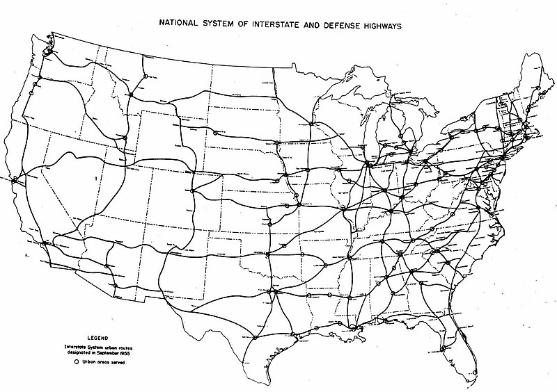
That, after all, is roughly how the Interstate System was built. Congress authorized about 50,000 miles to be built, and when a state got around to building a section, the Federal Highway Administration would simply distribute 90% of the necessary funds — no matter how complicated or “wasteful” the project’s specifics turned out to be.

Of course, with the funding formula for the Interstate highways, there was a great incentive for states to plan the biggest and most expensive freeway projects they could (often in urban areas).  Apply that same mindset to Minneapolis’ Southwest corridor or a New Blue line in DC, and you’ve got a positively reinforcing mechanism – instead of putting the most expensive highways where they’re lease effective, you put the most expensive transit systems where they can be most effective.

Such a set and defined set of plans would also allow for effective long-range planning.  One of the amazing things about DC’s Metro has been envisioning a whole system, and then executing it – rather than trying to have a go at it piecemeal.  And that kind of certainty and planning would enable better regional planning – not to mention the raw ability of infrastructure to attract and shape the form and location of development.