Monthly Archives: October 2009

Four ways to improve McMillan Two

(This is a follow-up post to Neil Flanagan’s initial post on GGW, as well as my own posts here and here)

The McMillan Two plan tackles a project of enormous scope, yet there are still several areas of the plan that need more emphasis.  The plan should be praised for its scope, vision, and long timeframe, yet as it stands, it is an incomplete idea that needs more depth to meet all the challenges DC will face over the next 50-100 years.

Similarly, the plan should be praised for its limits, as it lays out a skeleton for DC to grow around, rather than prescript every nook and cranny.  However, this limited breadth is also a major weakness in translating the plan from a handsome image into physical reality.

The following are four weaknesses in the current idea that could become strengths with the right amount of focus.

Transportation

The McMillan Two plan includes several implicit transportation initiatives.  Most notably, the plan calls for the full removal of the freeways flanking the Anacostia – both the Southeast/Southwest and Anacostia freeways.  Nir Buras notes that streetcars could be added to the plan, as his plan continues the framework of the L’Enfant grid and radial avenues, maintaining the wide rights of way that could be amenable to streetcars.  However, any other discussion of transportation is strangely absent from the plan.

While the L’Enfant plan laid out the skeleton to the city and the McMillan plan made Washington into the City Beautiful, the element that’s added (or re-added) the meat to the city’s bones over the past 30+ years has been Metro.   Metro has shaped suburbs and provided a mechanism for repopulating downtown.

Similarly scaled projects and plans around the world all feature substantial investments in transit infrastructure.  Both Canary Wharf in London and La Defense in Paris feature large transit investments.  Nir Buras might not like the form of these developments, but they fit the scope of McMillan Two.  In London, Canary Wharf features both the Jubilee Line extension while also serving as the hub for the massive investment of the Docklands Light Railway.
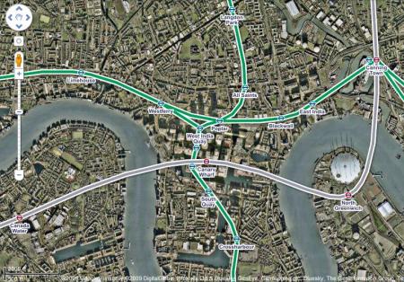
London DLR

Similarly, La Defense includes an extension of the Paris Metro line 1, while also serving as the terminus to the T2 tramway, as well as a stop along RER A.

Currently, the area along the Anacostia includes a couple of Metro stations in the vicinity, but if these new areas are to serve large new developments, they need infrastructure to support that growth – beyond just streets and bridges.  Even without McMillan Two’s narrowing of the Anacostia, transportation investments will be necessary for redevelopments in Poplar Point, the River Terrace power plant, and Buzzard Point.  These could be McMillan Two’s numerous bridges across the Anacostia, with or without the narrowed river channel.  Still, that framework is only one part of the equation – imagine what DC could do with a transit investment in the area on the scale of the DLR.

Green Infrastructure

By building off the principles of the McMillan Plan, McMillan Two is also building off the principles of the City Beautiful movement.   The City Beautiful asserted that grand, monumental spaces could foster moral and civic virtue amongst residents, and that a harmonious physical order would promote a similarly harmonious social order.

The track record for meeting these lofty goals is inconclusive at best, but the City Beautiful certainly left Washington and other places with many practical (and beautiful) enhancements.  Beautification efforts also tackled basic problems of infrastructure – sewers and utilities, sidewalks and streetscapes.   The common critique of the City Beautiful is that it is solely an aesthetic treatment for planning, yet many of its basic elements functioned quite well and continue to do so today.

McMillan Two appeals to the beautiful elements of that tradition, but it lacks the functionality.  Combined with the serious ecological concerns about narrowing the Anacostia, the functional elements of the plan seem to be in short supply.

However, the plan provides an opportunity, as well.  One impetus for the plan (as well as Buras’ selection of Paris as his case study) is DC’s currently poor relationship with the water.  DC urban waterfronts are in short supply, with only small stretches along Maine Ave SW, Georgetown, and Old Town Alexandria providing places where the city meets the water. Likewise, concerns over ecology and the Anacostia’s hydrology ought to be far more prominent in the McMillan Two agenda.

Together, these elements represent the opportunity to make this plan as the large scale, urban application of green infrastructure.  During his interview on the Kojo Nnamdi show, Buras rightly points out that the Anacostia today is in no way a natural river.  However, I believe we can both better connect the city to the waterfront while also mimicking natural marshes and ecosystems through the use of permeable pavings, bioswales, and other sustainable urban drainage systems.  To date, most of these applications focus on small-scale projects, but this plan provides the opportunity for a large scale application.   Furthermore, most of these drainage systems mimic natural ponds and marshes, and take their visual cues from those influences – this provides a chance to implement such systems in both an urban environment and in an urban design. How can stormwater detention and infiltration areas be effective public, urban spaces?

Like the transportation elements, use of this infrastructure is not predicated on narrowing the river.  It can be applied to any plan, and would hopefully become part of the best practices across the city.

Implementation

The single greatest aspect of the McMillan Two plan is its breadth of vision and scope.   Such breadth is also a challenge.  Both the L’Enfant and McMillan plans featured a grand vision and scope, but they were also easily broken up into manageable chunks, making implementation easy.  L’Enfant’s street grid took decades to build out, but surveying streets is a relatively easy task.  McMillan’s monuments and public spaces evolved over the course of several decades as well.

McMillan Two’s big move, narrowing the Anacostia, cannot easily be broken up into chunks (if it can be done at all in good environmental conscience).  For a plan with a scope of 100 years, you also need an implementation plan.

Potentially, it’s possible to meet all of McMillan Two’s goals without actually narrowing the river.  If you were to combine base re-alingment (as the plan displaces the Navy Yard, Bolling AFB and the Anacostia Naval Air Station) with the construction of new bridges, but without the narrowing of the river, you’d still have a large area to redevelop according to the plan without the hydrologic hurdles.

Input

Neil’s inital post on the subject generated quite a few comments.  This kind of plan requires public support, and gaining that support requires input from stakeholders through mediums like this.  Comments and criticism will make this a stronger plan.  My personal initial reactions to the plan have shaped my view of it, but only through a robust dialogue will the plan evolve beyond just the ideas of Mr. Buras and into a true civic vision for Washington DC.

Cross-posted at Greater Greater Washington

Columbus Weekend Links

I really like these Federal holidays when I actually get them off…

On airport transit service:

GGW had a point/counterpoint on how best to serve Dulles International Airport.  Spencer Lepler argued for using commuter rail along the Washington and Old Dominion right of way, while Matt Johnson argued in favor of the current plan, noting the greatly improved benefits, including access to Tysons Corner and other development along the toll road.   Johnson also noted the technical hurdles to reusing the old railroad right of way.

The entire idea of offering faster service between the airport and downtown DC motivates these discussions, and this isn’t limited only to DC.  Yonah Freemark notes the perils of Chicago’s Block 37 and the express airport service that doesn’t really exist.

In the end, express service to and from Dulles shouldn’t be a top priority.  The existing infrastructure certainly doesn’t make it easy to do so.

So what about the W&OD?  Matt’s post on the challenges to re-use the right of way also raise some potential uses – perhaps using the corridor, in addition to the Silver Line, as a light rail/interurban corridor might be a good use.  This allows at-grade operations in congested areas, as well as simplifying the terminal connection in Alexandria, either as a loop into Crystal City or as a connection to the new Potomac Ave infill Metro station.

With or without the Silver Line, however, I’ll still be looking first and foremost at DCA for flights.

First, convince the Bankers…

The Salt Lake City Tribune has a great article noting the biggest hurdle to transit-oriented development – the banks.

Transit-oriented development isn’t stymied by outdated zoning, unwilling developers or a lack of space. It turns out, banks, wedded to old-fashioned lending standards that stress parking, may pose the biggest blockade by denying financing.

The reason: Lenders operate from a tried-and-true principle that maintains more parking means less risk and a higher return on their investment. But ditching cars is the whole point of urban developers looking to create 24-hour live, work and play environments that hug light-rail hubs.

Take the capital’s gateway district, which soon could be further revived by a North Temple TRAX train, a new viaduct and millions in streetscape upgrades. City leaders envision a walkable, vibrant mix of housing, retail, restaurants and offices that one day will bridge the FrontRunner hub and a new North Temple transit station along downtown’s western rim.

But commercial investors, including one with a $100 million blueprint, complain banks cannot grasp the concept and instead slam their doors.

The first paragraph might be a little over the top, as outdated zoning, unwilling developers, and a lack of space are still huge hurdles, though I might change their language a bit.

Last week, there was plenty of discussion (BDC, RPUS, GGW) of the Post‘s article on DC USA’s woefully underutilized parking garage.  Valerie Santos, Deputy Mayor for Planning and Economic Development, noted the parking was necessary to convince any number of parties to build the thing – tenants, landlords, financiers:

The District has lost nearly $2 million — or $100,000 a month — since the garage opened in March 2008, numbers that make Valerie Santos groan when she considers the city’s decision to build the structure.

“I don’t want to say it’s a quote, unquote, mistake. At the time the District did what it had to do to attract a retailer it sorely wanted,” said Santos, deputy mayor for planning and economic development. “Am I happy about the operating deficit? Of course not.”

Obviously, there are lots of moving parts in any urban development equation, but overall education of all parties involved is a crucial element.

When speaking of performance parking, Dr. Shoup likes to advocate for removing parking restrictions from zoning ordinances and letting the market decide.  The challenge, however, is that this particular market is not acting with perfect information.  Rectifying that information gap is a huge challenge.  DC USA might have some use as an example of what not to do in the future, but that’s an awfully expensive lesson to learn.

Miscellany:

Some of the ugliest buildings in the world?

So says this list.  (h/t Yglesias)

Amtrak ridership is down…

…but still up over the longer tiemframe (Housing Complex)

Exit, stage left

DC Metrocentric takes a look inside the new Arena Stage.

The data wants to be free

Rob Goodspeed looks at municipal data sharing programs, and wonders what differences they make.

Metro track work

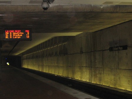
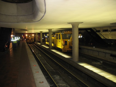
This past weekend’s extensive track work has come and gone.  I was riding the system through L’Enfant Plaza on Monday, and caught a few images from the work.

065-1

Yellow line to Stadium-Armory.

064

Track work equipment under the northern mezzanine of L’Enfant Plaza’s upper level.  Directly behind me was a flatbed car full of old switch tracks that were being removed/replaced from the crossover here.   I tried to grab a photo of that as well, but my camera died.

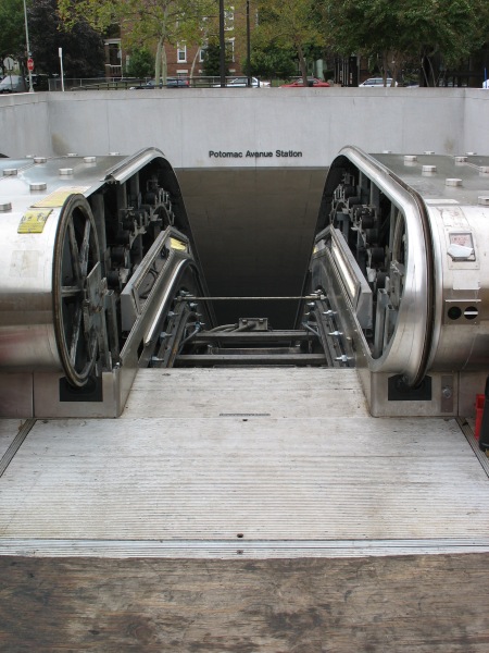
And, completely unrelated to this weekend’s specific work, escalator reconstruction at Potomac Ave:

066

Solar Decathlon

If you’ve strolled down to the Mall this weekend, you’ve likely run across a bunch of modern, high end trailer homes sitting out there as part of the Solar Decathlon.  I stopped by on my lovely Columbus Day holiday, and despite a lack of sunshine, the decathlon was in full swing.

ReadySetDC’s preview can be found here.

National Mall
(Between 10th + 14th Streets, Madison + Jefferson Drives)
October 9th – 13th, 15th – 18th

Some of my photos from today (again, sorry about the lack of actual sunshine):

[EDIT] DC Metrocentric has more, sunnier photos here [/EDIT]

The larger issue here, of course, is one of sustainability.  The relevant question is if ‘sustainability’ can really be captured within one single, easy to understand metric.  Building standards such as LEED assert just this.  As imperfect as they are, they’re at least a step in the right direction, so long as we recognize the limitations of those systems.  GOOD Magazine talks about ending LEED’s monopoly:

Because LEED buildings don’t have to perform up to spec in real life, LEED has contributed to a trend of showboating and point scrounging, leaving energy efficiency—arguably the most important metric—lost in the shuffle.

The average LEED building doesn’t even qualify for an Energy Star label.

Amidst a rising chorus of criticism, other standards are finally starting to get more attention. The Passive House standard, born almost 20 years ago in Germany, hones energy efficiency so finely that most certified Passive Houses need no conventional heating boiler. The overall energy use of a Passive House is around 70 to 80 percent less than a comparable conventional building.

Energy Star, like LEED, is a single rating metric, and as such, is subject to the limitations that a single metric imposes.  LEED, for example, includes points for recycled materials and water use, things that will be important for a truly sustainable structure in some locations.

Absent the larger debate on sustainability, the projects these student teams have put together are certainly worth a look.  I, for one, would love to see a discussion of how cities and the accidental environmentalists that live within them fit into the equation, as well as how these concepts and technologies can be applied to existing structures and urban environments.  However, it’s hard for me to envision how such ideas would fit within the current decathlon format.

Which is fine, so long as well all recognize the limits of these technologies and ratings.  Either way, check out these projects while they’re still on the Mall.

America's Metro

2008_0109_newmetro1

Last week, GGW’s daily links thread noted Metro’s consideration of moving to automated station announcements within trains, instead of the current announcements made by train operators.  The link included a look back to when Metro’s 7000 series railcars were first announced, more than a year and a half ago.

Automated announcements are one of those things that make it easy for those unfamiliar with the system to navigate it.   I can’t think of anyone saying this would be a bad thing, but it certainly removes a bit of the local flavor from the system.  DCist noted this last January, when the new car designs were initially revealed:

  • Automated station announcements. So no more “Judishuwary Square”.

This kind of local flavor is a small sacrifice in favor of greatly improved usability for most riders.  The more troubling aspect of the new car design, however, isn’t the loss of local character, but the bizarre rejection of Metro’s local connections.

As borne out by the DCist comments, perhaps the single most objectionable piece of the 7000 series design was the addition of the new “America’s Metro” logo.  Some see it as an egregious example of poor graphic design (and it is).  More troubling, however, is the fact that Metro is a local asset with a federal role.

Frankly, this isn’t America’s Metro.  It’s DC’s Metro.  Perhaps this logo was an olive branch to the Feds as a means to conjure up support in Congress.  However, the Metro is one of DC’s federal investments that’s paid tremendous dividends to the day to day life of the city’s residents.

The implications for Metro’s identity aren’t too promising, either.  Metro’s always had a strong, modern brand – thanks to the architecture, the unity within the system’s design, and the brand itself.  Since its creation, WMATA hasn’t always been the best steward of that design legacy.  However, the new bus liveries are promising and functional – hopefully this logo will be dropped from the final design for the 7000 series.

Washington Post Newsgraphic on 7000 series

Washington Post Newsgraphic on 7000 series

Technically, the 7000 series should be a welcome addition to Metro’s fleet.  However, let’s not sacrifice the system’s visual integrity.  Thankfully, those seat color schemes have not yet been decided.

These are not minor details, they matter.  Metro has bigger problems these days, to be sure.  That’s no excuse, however, to lower standards.

Cross-posted at Greater Greater Washington

ACS Data – How DC stacks up

Bike Pittsburgh, courtesy of Streetsblog, has some great, sortable data of how various cities stack up on the transportation aspects of the recently released American Community Survey data.   Bike PGH provides the context, ranking cities based on their percentages using transit, walking, biking, etc.  Looking at how DC stacks up against the other major cities in the United States gives a great deal of perspective as to how we’re doing as a city.

Again, remember that these are commute trips only, and for city residents only.  It’s important to understand the limitations of the data, but this is an even comparison for all the cities involved.  Obviously, this is still not an apples to apples comparison, as many ‘newer’ sunbelt cities are still aggressively expanding their city boundaries via annexation, while cities like DC remain both constrained by static political boundaries and surrounded by substantially urban jurisdictions (Arlington, Alexandria, etc).

Nevertheless, taking all of the statistics together gives a good sense of how DC stacks up.

Biking commute mode share:

  1. Portland, OR – 6.0%
  2. Minneapolis, MN – 4.3%
  3. Seattle, WA – 2.9%
  4. Sacramento, CA – 2.7%
  5. San Francisco, CA – 2.7%
  6. Washington, DC – 2.3%
  7. Oakland, CA – 2.1%
  8. Tucson, AZ – 2.0%
  9. Albuquerque, NM – 1.8%
  10. Boston, MA – 1.6%

Walking commute mode share:

  1. Boston, MA – 14.3%
  2. Washington, DC – 12.1%
  3. Pittsburgh, PA – 11.1%
  4. New York, NY – 10.3%
  5. San Francisco, CA – 9.4%
  6. Seattle, WA – 9.3%
  7. Philadelphia, PA – 8.6%
  8. Honolulu, HI – 7.9%
  9. Minneapolis, MN – 6.1%
  10. Baltimore, MD – 6.0%

Public transit commute mode share:

  1. New York, NY – 54.8%
  2. Washington, DC – 35.7%
  3. San Francisco, CA – 31.9%
  4. Boston, MA – 31.2%
  5. Philadelphia, PA – 26.8%
  6. Chicago, IL – 26.7%
  7. Pittsburgh, PA – 20.9%
  8. Baltimore, MD – 19.5%
  9. Seattle, WA – 17.7%
  10. Oakland, CA – 17.1%

Drive alone commute mode share (presented lowest to highest):

  1. New York, NY – 23.3%
  2. Washington, DC – 37.2%
  3. San Francisco, CA – 38.4%
  4. Boston, MA – 41.1%
  5. Chicago, IL – 50.5%
  6. Philadelphia, PA – 50.7%
  7. Pittsburgh, PA – 52.8%
  8. Seattle, WA – 52.9%
  9. Baltimore, MD – 57.9%
  10. Oakland, CA – 58.1%

All in all, that’s a strong set of rankings.  Bike PGH has the full sortable data if you want to take a deeper look.  For the sake of brevity, I’ve only listed the top ten in each category here.

DC stacks up well in these numbers.  The biking mode share is quite western (Albuquerque?), and transit mode share strongly correlates to cities with heavy rail rapid transit systems.

Commute Flows

Earlier this week, Lynda Laughlin at GGW noted a few key statistics about the District of Columbia, released as part of the Census Bureau’s American Community Survey.   Matt Yglesias honed in on the transportation mode share for DC residents:

When it comes to urban transportation, path dependency issues are everywhere. The more car-dependent people are the more political support there’ll be for car-promoting policies. Conversely, the more there retail and job opportunities are already accessible through non-automotive means, the more realistic it is for new residents to get by without a car, or for a family to get by with only one. And one interesting thing about the District of Columbia is that according to the Census Bureau we’re nearly fifty-fifty in terms of commuting patterns.

I don’t know that I buy Yglesias’ notion that DC is near a tipping point.  Certainly, non-auto transportation allows for density, which allows for more street level retail, which can allow more people to shift their lifestyles, etc.  These linkages are well documented, but the path isn’t linear, nor is it purely a market-based reaction – it requires infrastructure, policies to enable it, etc.

The more interesting discussion was on what this data represents.  This data comes from the American Community Survey, showing the mode of transportation of DC residents only (not workers) for their commute trips only.  This is significant because the focus on DC residents alone doesn’t give a full picture of the overall dynamics of the DC Metropolitan area, and the focus on commuting trips alone doesn’t capture the full use of the transportation system, since most of our trips are not commuting trips.

The latter point touches on Yglesias’ assertion that DC is close to the ‘tipping point.’  Arguably, such a point in an urban area would be when there’s sufficient density, diversity, and design to enable non-auto modes to dominate all of those trip types, not just the commute.

The former point, however, notes the Metropolitan emphasis.  And all of this was basically a roundabout way for me to link to this from The New Republic’s blog, noting the importance of emphasizing metropolitan policy over the loaded ‘urban’ policy terminology.  It’s not just arguing semantics, it’s a reflection of how our cities actually function.

Meshing that together with the commuting discussion, TNR has a great graphic of commuting flows in Chicagoland – which still has a huge and dominant downtown office market, yet still sees a wide network of commuting patterns:

I would love to see a similar image for DC.   Considering the relative size of downtown DC, with transit-oriented employment centers in Alexandria, Arlington, Silver Spring, Bethesda, and others, sprawling agglomerations in Tysons and the Dulles corridor, as well as proximate centers in Baltimore and Annapolis – I’ll bet it would make an interesting graphic.

Not dead yet…

So, the laptop repairs didn’t quite work out as planned.  A new machine is on order, but I’ve managed to commandeer a friend’s computer. 

Aw, thanks very much!  I’ll see you on Thursday.

Hopefully I’ll have some more substantive stuff up soon.  In the meantime, some quick notes:

More on the shortcomings of most libertarians when it comes to cities

I don’t want to lump everyone in one category, because there are some great thinkers out there applying libertarian thoughts to urban contexts, making sure to incorporate the histories, regulations, and subsidies into account.   Most, however, don’t follow that line of thought. 

BeyondDC points us to a great post from the Urbanophile:

I read articles out on the net with the general theme of claiming that a cabal of planners is conspiring to force us all to move back into overcrowded tenements in order to recognize their dream of reurbanizing America. There’s no doubt that plenty of progressives write about how people ought to more or less be forced back into the city. And I’m sure in some places there are planning rules designed to achieve this effect, like urban growth boundaries. But if you ask me, the practical reality in most of the United States is exactly the opposite situation. Virtually every piece of planning regulation I see acts to discourage urbanization and especially to reduce densities below market demand.

If you want people to live more densely, no nefarious planning rules are necessary. In fact, simply remove a lot of the ones we have and American cities would get much more dense in a hurry. The free market wants more density.

The whole thing is worth a read.   The assumption that planners who want more density are somehow communists or working against the benevolent hand of the free market is bunk – as is the assertion that the mere existence and popularity of McMansion-y sprawl is some magical manifestation of overwhelming demand for that lifestyle. 

While we’re on the theme of faulty assumptions…

Ryan Avent has a great post on Streetsblogon other faulty assumptions, particularly with what we consider inconvenient.  Namely, the assertion that Americans won’t chose to inconvenience themselves, whether by wearing a Jimmy Carter-esque sweater instead of fully heating the house in the winter, or using mass transit instead of the car (assumed to be both faster and prefered).  Europe is often cited as an example of a different lifestyle, yet the American choice of personal automobiles, larger houses, and the like are assumed to be ‘better.’ 

But there are lifestyle issues involved, particularly where transportation and land use are concerned. And contrary to Rosenthal, it isn’t that Europeans have opted for inconvenience. Rather, they have chosen different conveniences, as her Stockholm air train anecdote makes clear.

I think it is very difficult, objectively, to demonstrate that their choices have produced ways of life that are clearly less convenient than American lives. It is clear that Europeans tend to have better health outcomes than us, and they die in car accidents at much lower rates, and of course they’re enjoying levels of wealth similar to our own while producing half as much carbon.

The obvious retort to this line of thinking is that perhaps that’s all true, but like it or not America is now sprawling, and any effort to make the country greener by pursuing European land use and transportation options would be very difficult. In a similar vein, it is argued that attempts to push Americans into such a life via gas taxes or carbon prices would wind up being very painful.

But this is not quite right. As I have pointed out before, America will more or less need to build itself all over again by 2050 in order to accommodate population growth. Just because most of America is currently sprawling doesn’t mean that most of the America built between now and mid-century has to look the same.

Ryan’s exposure of the cultural differences points out, implicitly, what will be required to change these mindsets.  The important thing to remember is that we didn’t sprawl instantly, nor did we build our transportation infrastructure instantly.  The inevitable rebuilding of America will take place over the next 40 years, so there’s plenty of time to get the ball rolling in a more sustainable direction.

Cultural change starts at home.  If parents had the chance to downsize into an urban condo or other attached housing after the kids move on in life, perhaps this change could get started.  Now, if only there were some developers that wanted to build some urban density…