Monthly Archives: July 2009

Moving Time

Moving boxes by carlaarena on Flickr

Moving boxes by carlaarena on Flickr

Posting’s been light the last couple of days because I’ve been moving from one house to another.  No matter how many times I do it, I still forget what a pain it can be.  Now that I’m finally settling into the new digs, there’s been a whole lot of things worth commenting on posted in the past few days.

First, Richard Layman gave me a link on his blog, noting that we tend to disagree on a couple of things.  Though Richard and I do diverge on a number of issues, I think it’s worth noting that we’d agree on far more topics than not – including the general overall direction for the District and cities in general.   I’d also point out that a trend I notice in blog commenting in general (and many of my comments in particular) is that the truncated nature of the medium tends to focus my comments on one or two ideas from a post, and too often those ideas are critical rather than positive.  That’s the nature of the beast, I guess.

Thanks to Richard for having so much great info on his blog, I appreciate the link.

Poplar Point is a popular discussion item again.  GGW summarizes the development options presented, and Richard Layman chimes in.  Both note that all the options leave a little something to be desired.  One thing none of them have, however, is a soccer stadium – yet.  DC United officials have been chatting with Akridge about property they own, and is apparently still talking to DC officials about Poplar Point – though no one wants to admit anything.

All this stadium talk triggered a response from Noah Kazis at The City Fix.

While it’s good to see the Journal’s real estate blog thinking about neighborhoods rather than just individual sites, this is a common misunderstanding of how stadiums work. They aren’t vibrant providers of economic development; rather, they sit empty most of the time. The D.C. United schedule calls for 30 games a year, only 15 of which will be at the United’s stadium (not including playoffs, exhibition games and the like). That’s not enough to really spark development. While a built-in market of absolutely packed crowds at your sports bar is great for those 15 nights, the rest of the time you’ve got an enormous empty structure that will inevitably be surrounded by at least some large parking lots. That’s not a draw for street life.

First, I want to address a factual item.  DC United’s league schedule only has 15 home games, but DC United plays in several competitions beyond just MLS each year.  Just this past Tuesday I was in attendance at RFK for a game in the CONCACAF Champions League.  DCU also plays in the US Open Cup every year, plus there is also the SuperLiga, international friendlies, and plenty of games between National teams.  RFK will host the US Men’s National Team three times this calendar year, and has already played host to international matches between two non-US nations – drawing good crowds, too.

This issue of the number of games each year often is mis-stated, as most American sports fans don’t have experience with the idea of multiple, concurrent competitions as is commonplace in soccer leagues across the world (including MLS).  Most North American pro sports have their league’s regular season and then the playoffs – and that’s it.  Soccer has a whole lot more on the schedule, and it’s important to note that.

Still, I don’t think this changes the end result of Noah’s analysis.  Stadiums aren’t great for developing streetlife per se, but they can be an anchor to draw in crowds that would otherwise never venture into that part of the city.

I’d also argue that justifications for sports stadiums on pure economic grounds are misplaced from the start.  Sports are an important part of the civic identity of a city, and it’s important for cities to foster that connection.  Going so far as to hand over an expensive stadium on a silver platter (Nationals Park) probably crosses the line, but there’s something to be said for being a “major league” city.  DC United shouldn’t be an exception.

K Street’s transitway plans are moving forward, and not a moment too soon.  The two options at this point:

One option would create a two-lane busway in the center of K Street, leaving three general-purpose lanes on each side. The other option, on the other hand, makes the transitway three lanes, where the third lane lets eastbound buses pass each other in some spots and westbound buses pass each other in other spots. That option also contains a bicycle lane along the length of K Street. While at first glance the plans seem to provide a clear choice between more accommodation for cars versus more for buses and bikes, the difference isn’t that simple. Making a true “complete street” that works for all modes is not easy.

A nice debate emerged in the comments about bike lanes vs. trees vs. transit.  Leaving that discussion of priorities for another day, I’d offer one comment – I’d like to see a plan that can accommodate rail transit and buses on the same transitway in the space at the same time.  Seattle recently started doing this as they converted their downtown bus tunnel to handle both light rail and bus operations:

For any plan, I’d like to know how it could translate to rail in the future.  I would think that having some passing sections might facilitate streetcar, light rail, and bus operations.

Speaking of streetcars, Jarret Walker has a couple of great posts following up on the ‘debate’ between mobility and accessibility.  Also, along the same vein as trying to define the terms we use when discussing these issues, he has a great post about transportation planning in Australia and determining what values people want from transit.

One of the main reasons that skilled and talented people leave the transit industry is the impossibility of meeting conflicting political demands.   For example, I’ve actually seen cases where elected leaders told a transit agency to cut service on high-ridership route A in order to add new service to low-ridership rural area B, and then complained to staff when that change caused total ridership to go down. Obviously, if you move a service from a high-density area to a rural area, you should expect exactly that result. These hard-but-important questions are designed to elicit direction about the real choices that transit requires us to make, so that talented staff feel supported and encouraged as they follow that direction in building and operating the transit system.

This is the core of so many issues with transit, as well as the different emphasis on mobility vs. accessibility – our opinions of transit systems are expressions of value judgments.  Thus, it’s important to try and determine what those values are through the political process so that they can easily be implemented.

It’s similar to the idea of a community expressing their desires and values in a plan, then setting zoning rules to allow most development by-right, rather than the current mish-mash of PUDs, rezonings, variances, and the like.  Determine the values beforehand, rather than in an ad-hoc fashion while each individual case and decision festers.

Infrastructurist has a great interview with IBM’s HSR folks.

Matt Johnson has an intersting analysis of Metro’s ridership patterns.  More on this later, but the post is worth checking out now.

High Speed Notes

High Speed Rail seems to be the latest political sweepstakes – big prizes for those that go after some free money!  Yonah Freemark has a nice critique of a recent nationwide high speed rail proposal, coming from a recently formed lobby pushing for a nationally integrated system.

The new association, however, is already pushing an aggressive plan, as illustrated in their proposed network shown above. The proposal would sponsor the construction of 17,000 miles of 220 mph train lines, all electric, to be built out by 2030. The system would reach 44 states and stretch coast-to-coast…

Yet the motivation sustaining the development of a national plan is a good one — I pushed my own serious proposal on this blog earlier this year. Yet I am skeptical of some of the USHSR plan’s provisions. Specifically, I question proponents of high-speed rail routes that traverse empty areas of the country. This proposal’s inclusion of links such as those between Boise and Seattle; Salt Lake City and Sacramento; Denver and Kansas City; and Albuquerque and Dallas — each pair of which is more than 500 miles apart and separated by emptiness– stand out as attempts to make the system seem national without providing adequate justification for how these routes would be economically tenable.

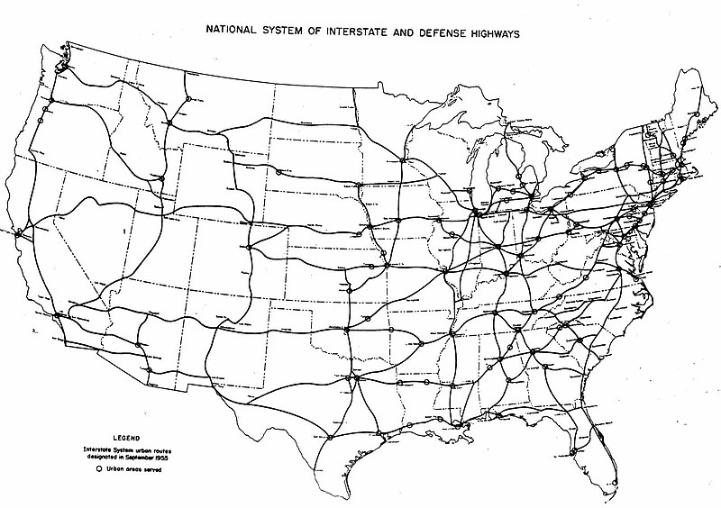
Yonah’s critique is spot on from the perspective of crafting a coherent national rail policy, but I think it misses the political element such a nationwide plan can have.  The Interstate Highway System shared at least some qualities with a project like the recently terminated F-22 fighter jet – it has lots of bits and pieces spread across many states, and hence, many constituencies.

Frankly, I find Yonah’s original nationwide proposal to be far more enticing as a matter of policy, too.  Still, I think it’s worthwhile to note that this group’s proposal is basically following the same general planning principle of the Interstate Highway System.  The system’s Yellow Book plans basically included links between each and every city of medium size in the entire United States.

1955 Yellow Book plan for Interstate Highways

1955 Yellow Book plan for Interstate Highways

Rail service alone might be transferable to a nationwide system (despite Amtrak’s financial struggles with the current long-haul routes), but high speed rail (and the expensive tracks it requires) don’t scale in the same way as roadways, obviously.  Nevertheless, the political calculus should be similar.

That kind of geopgraphic coverage is politically advantageous.  Granted, when the primarly funding mechanism was nationally collected gasoline taxes, such nationwide service then becomes a political necessity.  That’s where the high speed rail planning hasn’t yet tackled the key issue.  The initial inclusion of $8 billion into the stimulus package set off this planning frenzy, but $8 billion is clearly just a drop in the bucket of what will be required for even a modest network of “high speed” (read: 110 mph) trains.

Speaking of drops in the bucket, the bucket of potential ideas is filling rapidly.  Infrastructurist has a whole host of HSR notes last week, including some wonderful renderings of a potential new Anaheim station.  This station would serve the current Metrolink commuter trains, future California HSR trains, and even feature an extension of Disneyland’s Monorail to the station (unlike the Disney World monorail that crashed a while back, the Disneyland monorail is more of a ride than a transportation system – which might actually change).

It's a gas

Ryan Avent had a great post this weekend on the future of suburbs vis a vis their relationship with gas prices.   Some great poins all around about how our physical environment will change with expensive oil:

So, first of all, there’s this:

We will, in time, return to 1970s and 1960s levels of air passenger transportation. I do not expect technological advances to prevent this because the aircraft need liquid fuels – no electrically powered substitutes available. Boeing’s much ballyhooed 787 Dreamliner only boosts fuel efficiency 20%. Aircraft fuel efficiency would need to improve by multiples to compensate for Peak Oil and energy substitutes would have to be in the form of liquid fuels. Unless algae genetic engineering solves the problem we’ll do a lot more of our travel on the ground. Robert Rapier has explained better than I can the problems of algae biofuels.

I don’t know much about the potential alternative fuel or airline technologies, but I do know that last year’s oil price spike dealt a serious body blow to airlines. It seems to me that it will be much easier to handle rising oil prices on the ground than it will in the air. Intercity travel is very important, economically speaking, so this is a good reason, in addition to the environmental benefits, to invest in fast intercity rail. Highways are a very poor substitute for air travel.

In my mind, this is exactly right.  Even biofuels are questionable substitutes for air travel.  Heavier than air flight needs an energy source that’s extremely powerful when compared against the weight of the fuel.  The Air Force experimented with nuclear powered aircraft back in the ’60s, but couldn’t make it work.  There’s just no plausible alternative to hydrocarbons for air travel.

The implication, of course, is that a future with expensive oil would put a much larger emphasis on rail for intercity travel.  Airlines will still serve long haul and international routes, as even the fastest trains can’t compete on transcontinental and (obviously) intercontinental routes.

For cities, this is a tremendous long-term opportunity.  Airports are tremendous gateways for cities, but the nature of air travel and the space it requires for runways, terminals, hangars, safety zones, etc is extremely unfriendly to urbanism. Rail terminals, on the other hand, have a much better history of integrating well into the urban fabric and urban transportation systems.

Not that airports would be useless – to the contrary, this would be an opportunity to integrate rail and air travel.   In DC, a site between Crystal City and National Airport has potential to do just that.

Much of the remainder of the discussion centers on high gas prices forcing a return to urbanism in a large scale. Avent:

When urbanists like myself argue in favor of better policies, it is (generally) not with the belief that we all should or ever will live in very dense urban environments. Rather, I think that we should improve policy, and that the result will be slightly fewer living in low-density environments and slightly more people living in high-density environments. And it’s worth pointing out that “high-density” can mean many things — everything from Midtown Manhattan, to the walkable rowhouse neighborhoods in the District, to transit-oriented neighborhoods in places like Arlington where dense development around transit hubs rapidly gives way to detached but compact single-family homes. To the extent that any urbanist out there is arguing that everyone must live the condo and Whole Foods life, I’m ready to declare that they’re wrong.

I agree completely.  “Urban” densities can range anywhere from Manhattan to compact, single-family home areas interspersed with a few apartments, condos, and mixed use neighborhood retail areas. Likewise, ‘urban’ densities do not need to be in ‘urban’ locations.  Many people don’t want to live in the big city, but like walkable urbanism nonetheless.

What’s more important in my mind is to set the rules so that such densities (and the requisite pedestrian-friendly designs and land use patterns) are not just possible, but encouraged.  Avent notes this as well:

It seems pretty clear that government policy — via things like highway subsidies, mortgage-interest deductions and FHA lending, zoning rules, and so on — has strongly encouraged suburban development over the past half century. The market has therefore provided too much suburban style housing and too little urban housing.

It’s not just about understanding how we got here, we also have to change those rules so that urbanism is no longer illegal.  We need to adjust surface transportation policies to build more transit lines instead of freeways.  We need to make rental housing a more attractive option – or at least avoid stigmatizing renters or overly favoring homeowners.

All in all, rising gas prices will continue to provide a great way to frame how all of these issues are interconnected.  My gut tells me that people are understanding these realities far better now than they have in the past.

Lecturing…

I’ve been going through some of Spiro Kostoff’s lectures from his teaching of a course at Cal in 1991.  The lectures accompany Kostof’s research for his 1991 book The City Shaped.  I mentioned the lectures previously here, but they really help illuminate Kostof’s book.   The book is easily the best primer for the history and elements of urban design I’ve come across.

The full list of videos available from Cal is available here.  All in all, there are 25 lectures to choose from.

As a complete aside, 1991 obviously predates PowerPoint – it’s interesting to see a professor delivering a lecture with actual slides.  Needless to say, this was not quite my academic experience.

Polycentricity

VRE Train.  Image from Ouij on Flickr.

VRE Train. Image from Ouij on Flickr.

Nobody would argue with the idea that DC’s commuter rail system could be better.  Metro, however, is largely praised (disaster responses and publicity notwithstanding).  However, Metro also gets attacked in some quarters for its hybrid nature as both an urban subway and a commuter rail system.

Richard Layman in particular likes to emphasize the writings of Steve Belmont.  When talking of transportation, Belmont contrasts monocentric transit systems (essentially dense hub and spoke networks with all lines serving a dense core) with polycentric ones, where the city has many nodes and thus requires many links between them.  Belmont (and Layman) argue that polycentric is bad and monocentric is good – at least at encouraging dense development and urban living within the core.  The problem, however, is that the monocentric/polycentric division isn’t all that useful when only comparing one system to another.

Belmont’s two main criteria for determining the centricity of rail transit systems are station density and the spatial extent of the system.  Metro in DC fails on both accounts, as it has long ‘tail’ lines and stations separated by long distances.  However, within the core, the station density is actually quite high – extremely high when you consider the context and time it was built (as opposed to the older systems in New York et al with predominantly cut and cover construction).

Paris, on the other hand, is the textbook case of monocentric rail transit, Belmont argues.  Paris’s Metro has more line miles than DC’s Metro, but all of them are squeezed into an area no more than 7-8 miles in diameter.  Likewise, there are far more stations within that smaller area.  It’s an incredibly dense system.

Where the comparison breaks down, however, is the limitation in comparing one system to another.  DC’s Metro is a hybrid system and needs to be analyzed as such.  To make it as close to an apples-to-apples comparison, you’d need to analyze a combined system of both Paris’s Metro and RER.

Jarrett Walker did just that.  The end result is that Paris’s employment patterns are far more polycentric (and as Walker argues, more akin to Los Angeles rather than New York) than Belmont might imply. Walker’s starting point was Alon Levy’s proposal for through-running commuter rail trains in New York (Part 1, Part 2), a theme I picked up on with ideas for DC’s commuter rail system.  Walker writes:

But when you start looking at the cost/benefit of all the tunnelling to get the various commuter lines connected to each other, you stumble on an important difference between Paris and New York.  For all the suburbanization of the last 70-some years, New York still has an world-class concentration of jobs and activities in a very compact core (roughly the southern half of Manhattan plus inner Brooklyn).  For trips from the outer suburbs to this core, it’s not hard to get where you’re going with the existing commuter rail line and one connection to the subway.

Paris commutes are widely distributed to major employment centers located mostly on the edges of the city.  This pattern particularly cries out for RER-style through-running of commuter rail because so many people are commuting to a center on the far side of the city from their origin — for example, from suburbs east of Paris to La Défense in the west.  Greater New York would benefit from such an arrangement, but not nearly as much as Paris does.  For New York it’s a nice feature, but for Paris it’s foundational to the growth pattern of the city.

Polycentricity is the fundamental pattern for the region.  This statement could apply just as easily to DC (especially in terms of employment clusters) as it does for Paris, which is why the through-running concept is so attractive.  The Overhead Wire has some great images talking about how we shape that polycentric reality that most cities deal with.

Walker’s takeaway message is this:

Los Angeles and Paris have come to their similar structures by very different paths, and have drastically different cultures of planning.  But urban structure is destiny because it changes so slowly and incrementally.  The constellation of major centers in both cities is a tremendous advantage for transit: people are flowing in all directions to centers on various edges of the city, so there is a huge area in which transit demand is two-way.  By contrast, suburban commuter service into New York will always be a story of trains and buses flowing empty or nearly empty in one direction so that they can run full in the other, because the concentration of jobs in the center is so massive.

I can’t think of a better vision for DC’s future – a dense core employment area, surrounded with high density neighborhoods – and other employment centers around that (Rockville, Bethesda, Silver Spring, Alexandria, etc).  Enabling, where possible, DC’s commuter rail system to offer through-service to those centers would be a huge improvement in service for DC’s current (and future) economic geography.

DC's odd-shaped public spaces needn't be awkward or neglected

Longfellow Monument.  Photo by NCinDC on Flickr.

Longfellow Monument. Photo by NCinDC on Flickr.

In terms of urban design, Washington DC is unique amongst American cities.   Between the height limit and the monumental core, DC’s plan is befitting of a national capital.   Grand avenues, civic spaces, and prominent monuments.  L’Enfant’s grand plan was not just for the nation, but for the local community as well.  Too often, however, many of the interesting local spaces created by that grand plan have been taken over by cars, fallen into neglect, or both.

Despite its grandeur, the L’Enfant plan isn’t universally loved.  Matt Yglesias takes issues with DC’s “triangles of doom,” while citing Bostonian Noah Kazis’ learned love for DC’s grid and avenues over Boston’s colonial mishmash of streets.  Yglesias notes:

I think there’s definitely something charming about metro Boston’s tangled web of streets. And there’s clearly also something good and practical about a regular grid. But I really don’t think there’s any case at all for what we’ve done in DC in terms of super-imposing diagonal boulevards on a basically rectilinear grid.

Yglesias touches on three major aspects of city design – the “organic” pattern, the grid, and the diagonal.  “Organic” networks, such as Boston, are really not organic so much as they are unplanned.  This is not always the case, as there are plenty of planned cities designed to look like “organic” street networks.

DC, on the other hand, is clearly a planned city, at least within the confines of the L’Enfant Plan.  Outside of the L’Enfant city, Adams Morgan exhibits plenty of “organic” patterns – but the iconic streetscape for Washington is definitely L’Enfant’s radial avenues superimposed on a rectilinear grid.

What Yglesias misses, however, is clear case for DC’s avenues.  We can never forget that Washington, DC is not just a city, but the capital of the United States – and the urban design of the city reflects that fact.  Spiro Kostof, in his book The City Shaped – Urban Patterns and Meanings Through History, calls this kind of capital monumentality “the Grand Manner.”  The Grand Manner, Kostof writes, “is not the currency of little towns.”  Indeed, in his chapter on the Grand Manner, an aerial photo of Washington, DC occupies the entire initial page. These are not supposed to be purely functional streets, though Daniel Burnham and other practitioners of the City Beautiful would argue they are helpful.

DC’s diagonal avenues are an important element of this grand aesthetic.  They provide vistas to key buildings and monuments, and though they are geometric in plan, they also respond to key travel patterns in the region (such as Connecticut Avenue and New York Avenue).  These diagonal streets are also not unique to Washington, as Chicago, Detroit, and others have important diagonal streets superimposed across urban grids.  In modern function, streets such as Broadway in New York predate the grids they bisect, but nevertheless function in similar ways today.

Even ignoring the political implications of such streetscapes, the creation of small triangles, nooks, and crannies within the grid should be seen as a positive.  From the national perspective, these were seen as locations for monuments.  From the local perspective, L’Enfant (and later Ellicott) ensured a public circle or square to serve as the focus for each section of the city. Likewise, the radial avenues connect these parts of the city to each other with both direct lines of communication and transportation.

However, Yglesias isn’t convinced.  He notes this kind of planning “leads to lots of very weird intersections.”  As an example, he cites the intersection of New York Avenue, H St, and 13th Street NW as a confusing intersection for drivers and pedestrians alike.  Tellingly, Yglesias uses a Google Maps image to illustrate this.

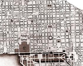
The Google map, however, focuses on the auto circulation routes – not the public space.  When looking at either the L’Enfant Plan or the Ellicott Plan, neither of them delineates traffic lanes or vehicular circulation.  Instead, those plans focus on defining the street as a public space.  Likewise, most of DC’s circles and squares are defined not by the traffic patterns of the streets, but by the blocks that surround them.

L'Enfant Plan_detail

Detail of the L’Enfant Plan.  Note the lack of design within the public squares.

The awkward intersections of auto traffic are a relatively recent occurrence, not a hallmark of the plan.  Yglesias understands this, at least at an intutive level, since he made a great suggestion several days later about improving traffic and pedestrian space within one of L’Enfant’s many squares.  These kind of discussions are not new to DC, as many squares from L’Enfant’s plan do not function as squares at all.  Traffic bisects them – at Eastern Market and Potomac Avenue for example, proposed changes would open up these spaces.

Likewise, there are many triangles and small parks at the intersections of DC’s radial avenues and the grid.  Some house interesting public spaces, while others are substantially underutilized.  Since we have them, it’s up to DC to make use of these small spaces.  Yglesias notes:

But worst of all they create these horrible dead spaces when the wedges between the various streets are too small to put a city block on. Every once in a while this process results in a “triangle park” that’s actually nice and used for something (the part at 1st, R, and Florida has nice synergy with Big Bear Cafe and the Bloomingdale Farmer’s Market) but the typical triangle park isn’t really used for anything and many of them scarcely deserve to be called parks.

Green space and public space are good things, but they’re really only good if the spaces are usable and used in practice by the people who live and work in the area. That requires them to be located and sized for real reasons (”this would be a good place for a park”) and not just used to fill up awkward gaps in a street grid.

Indeed, many of these triangles are underutilized.  However, this is a problem of programming, not of design.  Kostof notes in a video of a 1991 lecture series accompanying his book that L’Enfant’s plan specifically avoided those cast-off spaces Yglesias worries about – each public square was to be programmed as a focus for a neighborhood.  They were not just used to fill in the gaps of the street grid, and they need not be treated as such today.

Instead, the challenge is to re-program these spaces, as exemplified by the Bloomingdale Farmer’s Market.   Not every space needs to be active or monumental, but there are plenty of opportunities to improve and enhance DC’s public spaces.

(Cross-posted at Greater Greater Washington)

Good News, Bad News

Some good news here in DC:

Ryan Avent notes that despite the recession, the District is still a popular destination for people moving in.  It will be very interesting to see where DC’s population number ends up with the 2010 Census.

Bad news:

Construction within the District is way down from a year ago.

But there’s more good news!

Union Station’s bike station has glass!

From around the nation, some other promising tidbits:

72% of Charlotte’s LRT riders hadn’t used transit before.  Like The Overhead Wire, I think that’s a huge number.  Some of it might be to good timing with the nationwide increase in transit ridership and gas price spikes coinciding with the opening of the line – after all, you never get a second chance to make a first impression.  Still, that’s a fantastic number and shows the kind of bias for rail potential riders have.

Small scale solutions to water issues get some publicity in Roll Call.

Most of us think of water and wastewater infrastructure as consisting of big pipes, treatment plants and reservoirs. Few of us recognize the importance of our natural infrastructure — the forests, wetlands, flood plains and grassy, permeable landscapes, which filter and purify water for humans, provide habitat for fish and wildlife, and mitigate hot summers in city and town. Our natural landscape provides us with the most cost-effective and efficient system for recycling, reusing and filtering water.

This way of thinking has to change. Our infrastructure is aging. We pay relatively low water rates, which fail to cover the full value or cost of clean and safe water. We are losing more undeveloped land each year along with its trees, shrubs and grasses and are replacing it with impervious surfaces — roofs, roads, parking lots — that allow pollution to be carried off into our waters. We find ourselves in a changing climate, whatever the cause, bringing with it chaotic weather patterns including droughts in some places and greater precipitation and polluted runoff in others.

This kind of small scale thinking is something the Feds should encourage cities to take on, as it fits into their purview far more than, say, massive and expensive deep tunnel projects.  (Hat tip – Infrastructurist)

And one bit of bad news from New York: The Feds don’t like the delays and budget projections for the Second Avenue Subway.

The story is simple: The MTA has been unable to meet any of its self-imposed deadlines, and it now faces the prospects of massive cost overruns and a six-year delay in delivering Phase I of the Second Ave. Subway. Original plans called for the entire line to be constructed by 2020. That is but a pipe dream right now.

The FTA numbers are alarming. The MTA is budgeting for an expected cost of $4.451 billion with a high end of $4.775 billion. The FTA believes a low budget estimate to be $4.978 billion with an August 2017 completion date. The federal government’s high end is $5.728 billion — over $1 billion more than the current MTA estimate — with a June 2018 opening date.

It’s too bad, since mismanagement like this (and Boston’s Big Dig also comes to mind) turns people away from thinking big and long term.

More investment, please.

It’s all a matter of time horizons.  If you have a long term investment horizon, you can think big.  If you’re thinking short term, you need something that makes an impact right away.  As this applies to transit and transportation planning, it’s much easier to implement a service, such as a bus route than it is to plan, design, and build a rail line.

Advocacy for change is important, but some are annoyed with the focus on the near term instead of keeping our eyes on the long term prize.  The Overhead Wire takes Streetsblog to task for perceived Bus Rapid Transit advocacy.  Buses are great, and we should certainly invest in them and upgrade them wherever possible.  But we also should acknowledge that they don’t have the long term impacts that rails do.

You want less people to ride transit? Then build inferior transit. In all actuality though, this country needs more Metro Subways. You know, the kinds of things they have in first world countries on the European continent. Washington DC is an example of a place that has developed more recently around the subway. Regions that build BRT will always be car cities. If you want to truely transform regions, we’re going to have to think bigger.

I think a lot of people talk about Arlington County because of the great success it has had in development. Yet no one talks about what Atlanta was like on Peachtree just north of downtown or in the Buckhead area just north of there before MARTA. Not a lot of people seem to realize that San Francisco is much more dense now because of BART and Caltrain connections as well as the Muni Metro than it ever would have been without. In fact, certain companies have pushed the MTA in San Francisco to make Muni better or they will leave. They wouldn’t be saying that if we had a system that actually worked.

The problem with places like San Francisco and Atlanta is that they didn’t go far enough. They built a couple of lines and then stopped. If we truely want to see our cities transform, we need to go further and without BRT as THE substitute idea for Heavy Rail or Semi Metro Light Rail. It’s an outrage to think that people actually think this is a real alternative to transform our cities and turn the population to transit. It’s just us being cheap. We’re already cheap with transit, and look where that gets us. To more people riding cars and more sprawl.

It’s important to note the Arlington County case.  The “Oranjington” corridor is always hailed as a paragon of transit oriented development.  And it is.  But any quick glance at aerial photos from that area shows plenty of surface parking lots yet to be redeveloped:

That section of the Orange line opened in 1979.  We’ve made a lot of progress in 30 years, but the long term land use changes and reinvestment in those areas takes time.

Ryan Avent takes it one step further:

It seems to me that the only thing more remarkable than the great success cities have had when they’ve focused on improving land use around fixed-guideway transit is the fact that cities seem so reluctant to repeat the experiment. Metro’s Green Line through the District has been a gold mine for the city, leading to billions in new investment, thousands of new residents, hundreds of new businesses, and so on. And there is absolutely no momentum in the District’s government to try and create more opportunities for this kind of growth.

I’d suspect the reason for this is precisely because of the long term time frame.  Add in cost factors, and thinking this big is simply not going to happen for most municipalities.  Perhaps regional entities could do better, but the Feds also have to be on board:

A big part of the problem, of course, is that the federal government doesn’t adequately take these kinds of land use changes into account in allocating funds. It’s nonetheless possible for cities to press ahead with these things, particularly since attitudes in Washington are changing. You’d think that someone down in the city government would be like, you know what? That worked really well. Maybe we should do it again.

Indeed.  However, going at it ‘alone’ is a tough road.  It’s somewhat heartening to see Senators considering transit within the climate bill, but transit’s biggest potential isn’t in energy savings but in land use changes.  These kinds of land use changes will make transportation cleaner all by themselves as well as slowly make carbon-friendly lifestyles more accessible to the population of America’s cities.  So many of the problems we face in terms of climate change stem from our land use patterns, yet we treat them as fixed when discussing solutions.  Again, some long-term perspective is in order.

Future ideas for DC's commuter rail system

MARC Train. Image from J.H.Gray on Flickr

MARC Train. Image from J.H.Gray on Flickr

Washington, DC is blessed to have Metro – a great urban transit system.  It’s probably the single best thing to happen to the city in the past 50 years – and even more notable considering the era it came from.  When most cities were depopulating and building freeways instead of transitways, DC built a subway system.  Several cities built subway lines, but DC managed to build an entire system.  Given the dominance of the automobile both in public policy and in public perception during this era, this accomplishment is nothing short of remarkable.

However, the success of Metro can sometimes hamstring future transit discussion in the region.  If people want transit, they want it to be Metro.  Even if Metro (specifically – heavy rail rapid transit – fully grade separated) isn’t the best option for the job.  Rapid transit lines are tremendously expensive and must have high ridership to justify their expense.  Still, when people talk about expanding transit in the DC region (which is good!) they tend to focus on simply extending Metro lines places.  Plenty of folks point out the oddity of putting the most expensive mode of transit out on the fringe – especially when some of those places (Orange line to Manassas, Blue Line in NoVA) already have existing commuter rail connections.

Some of that stems from the hybrid nature of Metro.  Unlike her sister system in the Bay Area, Metro at least functions as a more traditional subway within the core of DC.  However, out on the fringe, the rail speeds, station spacing, parking supply, and distances covered function much more like a commuter rail system than a subway.  Thus, it’s somewhat natural for people in the region to associate a commuter rail trip with Metro’s brand – but that doesn’t make it the best choice of mode.

The solution seems blindingly obvious – many of the corridors mentioned for Metro extension, whether that’s the Orange line to Manassas, the Blue line to Ft. Belvoir, or the Green line to BWI – are already served by commuter rail.  The issue is that commuter rail service in the DC region is sub-par.   MARC and VRE simply don’t have the good brand name that Metro does, and for good reason – the service they offer is inferior.

Plenty of people have opined about future commuter rail service in DC, including both MARC and VRE themselves. I won’t bother to re-hash what are essentially obvious arguments – bring MARC and VRE under one brand, increase headways, increase hours of operation, essentially make these services more like transit rather than just commuter rail.   Similar services in other places, whether being German S-Bahn services or even New York City’s commuter railroads show how these modes can both serve as express transit services as well as reliable transit.

The genesis of this post was simply a couple of things that came up during the past week.  First, BeyondDC made a few predictions on the state of the DC region in 2040.  The one observation that struck me concerned a future second intercity rail station in the area:

Intercity Travel:
Union Station will be past capacity and we will need a second depot, possibly in Arlington. There will be multiple trains per day running several short-distance intercity rail trips to all other population centers in the mid-Atlantic region. Camden Station will become more important in Baltimore. Dulles and BWI airports will continue to expand. National Airport may be sold and the land redeveloped, or it may continue to operate, depending on how much intercity travel continues to be done by plane.

The potential for a second major rail station in Arlington is intriguing.  It also dovetails nicely with this guest post on the transport politic about the future of regional and commuter rail in New York City.  The post harps on one key principle for New York, also applicable to DC – through-routing of trains:

The New York metro area has many stub-end terminals—Flatbush Avenue, Grand Central, Hoboken, Long Island City, St. George—as well as one station, Penn Station, which is a through-station by layout but a terminal by use, except by Amtrak. Such a configuration works in getting people to take commuter rail from the suburbs to Manhattan, but is inherently limited for all other functions…

Manhattan acts as a barrier to transportation, both by auto and by rail. By train, one needs to transfer. By car, one needs to cross jammed roads and pay multiple tolls. Through-running is a way of breaking this barrier by enabling people to live in North Jersey and work in Queens and Brooklyn, Long Island, or Connecticut, and vice versa. Though some people live on one side of Manhattan and work on another today, the current stub-end use of Penn Station lengthens those commuters’ travel time and restricts their number.

Worse, the stub-end layout reduces track capacity. A rapid transit train can dwell at a through station for under a minute, even if it is crush-loaded with passengers trying to enter or exit. At a terminal, the minimum dwell is about five minutes, and mainline trains discharging all or most passengers at the terminal typically dwell more. This clogs the tracks, leading to the absurd situation that while the RER’s central transfer point, Châtelet-Les Halles, serves 500,000 daily passengers on 6 tracks, Penn Station strains to serve 300,000 riders on 21 tracks.

Both MARC and VRE want to route trains through Union Station to serve regional destinations.   For MARC, the obvious choice would be serving employment centers at L’Enfant Plaza, Crystal City, and Alexandria directly.  For VRE, the same principle applies to Silver Spring and even through to Fort Meade and Baltimore.

Combine those ideas with the notion of both expanding regional and intercity rail service, and such routing options could increase the effective capacity of Union Station’s lower level through-tracks, as well as probably create demand for expanded facilities in the DC region.  The potential for inter city from points south (Richmond, Charlotte, Atlanta) terminating at an Arlington station is an interesting idea, creating a situation akin to Boston’s North and South Station – but with the needed track connector between them.  Likewise, Philadelphia’s through-routing regional rail shows the potential advantages of such a system.

This new terminal could easily fit on the land between National Airport and Crystal City.  The potential for connections between rail and air service is also interesting.  The location would provide an adjacent ‘downtown’ with Crystal City, but also a very short trip into Downtown DC via the Yellow line.

Both of these concepts – through routing and provisions for a new major terminal in Arlington – should be included in any future plans.

Counter-intuitive traffic

Perhaps the most confusing element in convincing the public about certain traffic improvements is the fact that traffic often behaves counter-intuitively.  We often think of traffic like water – if you remove some capacity from a stream, that water has to go somewhere.   In fact, traffic often behaves more like a gas – it expands to fill the volume given.  Conversely, when space is restricted, the same amount of gas will still fill that volume.

Obviously, this is a gross oversimplifaction of things.  The context of each situation matters a great deal, but for the most part, traffic fills the space available to it.

With that in mind, there are a couple of nice pieces circulating about traffic and how we deal with it:

Streetfilms visits the closures of Broadway at Herald Square in New York, noting how this particular closure has both increased available pedestrian space as well as improved traffic flow by vastly simplifying complex turning movements.

In a similar vein, Tom Vanderbilt (of Traffic fame) has a great piece up at Slate concerning the rise of the roundabout and some of the counter-intuitive effects they have.  Vanderbilt notes the disconnect between our common perceptions about roundabouts and the reality.  For example, we think they’re unsafe when they’re actually more safe.  We also think they’re slow (which they often are) yet they manage to move more traffic through the intersection in the same period of time – slower top speed, but faster average speed.

Ryan Avent has a couple of interesting posts on the potential for charging for roads based on vehicle miles traveled, rather than gallons of gas consumed.

The first concerns tolling technology.  The University of Minnesota has a cheap and easily installed device that could track miles traveled using mostly existing technology from on board car computers and SMS text messaging – thus using cell phone services rather than GPS based technology.  Such a device would seem to be both more cost-effective than GPS based systems and would also ameliorate some of the big brother privacy concerns with a VMT tax.

Discussion in the comments quickly returned to the idea of why a VMT tax is even necessary – why not just increase the gas tax? Avent’s second post takes this question on:

Several things to note. First, as I mentioned in the original post, this technology might also make it easier to do congestion tolling, which would be of enormous economic and environmental benefit. Second, I think we should increase the gas tax, whether or not we adopt a VMT. Oil dependency is pretty obviously a nefarious economic force, and I think it’s worth encouraging drivers to get off the black stuff. I’m also clearly in favor of carbon pricing, which would have a small but positive impact on gas prices.

Third, increasing gas taxes isn’t a very good way to pay for long-term infrastructure expenses, because higher gas taxes make people use less gas. So you increase the tax, and then people substitute away from the tax, reducing revenue, and then you can increase the tax again, and consumers will substitute away even more and revenues fall again, and so on. Higher taxes encourage efficiency, then a move to hybrids, and then a move to electrics, at which point you no longer have any tax revenue.

All good points.  Raising the gas tax now will help bridge the gap we have in transportation financing, as well as provide some much needed incentives to continue the shift towards both driving less and doing so in more fuel-efficient vehicles.  But this obviously is not a long term solution, and that’s where a VMT tax comes into play.

The devil, of course, is in the details.  Using VMT as a revenue stream is a great idea in the abstract, but that presumes heavier, road-damaging trucks will be taxed more than light cars.  As Ryan notes, linking such a mechanism with the ability to charge tolls is also an intruiging idea, as not every vehicle mile is equal.

Nevertheless, this will be the front line for the new transportation bill.  Without a stable funding source, financing infrastructure improvements will be difficult.

Also on the Avent watch – Ryan has a nice smackdown at Streetsblog of some conservative think tank dreck on the transportation front.